The kibuga: Buganda’s lost capital
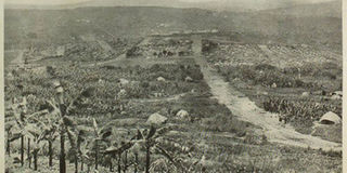
Kampala as seen from Namirembe Hill in 1897. In the middle is Lugard’s Fort. PHOTO COURTESY OF HENRY LUBEGA
What you need to know:
Significance. To the Baganda, the kibuga (city), was the epitome of their pride, military life and political administration. It was also a symbol of a cultural centre. The place was co culturally important to them that non-Baganda were not allowed to enter without permission.
Kibuga is a Ganda word for city. Years before Buganda Kingdom was exposed to the outside of world, it had its kibuga. However, during the different reigns of the different kings the kibuga moved according to the king’s wish.
From the time of Sunna II’s death in 1856 up until 1890 when Frederick Lugard arrived in Buganda, the kibuga had moved to 10 different locations. At the arrival of the first European, John Speke, in Uganda (Buganda) the kibuga was in Bandabarogo (present day Banda) where he met Mutesa I. While Rev C. T. Wilson met him at Rubaga in 1875, Mutesa I had another palace at Nabulagala. But since 1885, Mengo has been the seat or kibuga of the kingdom.
The kibuga was located in Kyaddondo, one of the counties created by the 1900 Buganda agreement. In Roscoe’s book, The Buganda, he describes the kibuga to have had wide and well swept roads “…the principle roads were about 20 yards wide, others were narrower, while the small branch roads were not more than three yards wide. The Katikkiro would send orders into every part of the country (Buganda) telling the people to come and repair the roads.”
Though in the earlier days there was no tangible size description of the kibuga, the first size description was done by R. F. Burton in his book The Lake Region of the East Africa published in 1860.
In the book Burton relied on the information collected by Snay Bin Amir, an Arab trader, who described the kibuga as “…the settlement is not less than a day’s journey in length, the buildings are of cane and rattan. The sultan (Kabaka)’s palace is at least a mile long and the circular huts neatly arranged in line are surrounded by a strong fence which has only four gates.”


The first survey of the kibuga was done in 1907-1908 by H. B Thomas and A. E. Spence, who put the kibuga’s size at 20sq miles. It covered areas such as Nateete to the west of Mengo, Kibuli in the east, Mulago in the north and Kabowa to the south.
It was not until 1890 that the future if the kibuga was threatened by the coming of Lugard and the setting up of what in his book The Rise of an Empire he described as: “He (Mwanga) gave the little knoll on which my camp was pitched named Kampala, also the plantation at the foot of the shortest slope which I greatly desired to acquire as it was owned by the rowdy set belonging to the Fransa (French) who were continuously creating a disturbance.”
To the Baganda, the kibuga was the epitome of their pride, military life and political administration. It was also a symbol of a cultural centre. The place was so culturally important to them that non-Baganda were not allowed to enter without permission.
When in 1899 the Counsel in General signed a notice under Article 99 of the Queen’s Regulation, providing for certain sanitary rules for an area with a radius of three miles of Mengo, the Buganda government protested.
According to the Buganda archives file s.12/00, in a letter dated February 22, 1900, from the Katikkiro to Sir Harry Johnston, expressed their fears that the passing of the ordinance is going to be a threat to their pride. The Katikkiro in his letter said: “Our very great fear that this notice will give the Europeans in their place a great power over our kibuga.”
The Katikkiro, Sir Apollo Kaggwa, was supported by a number of local chiefs through a letter written by the Sekibobo of Kyaggwe saying, “I fear very much what has happened, and the Europeans must not eat our land which has belonged to our kings and our forefathers.”
However, writing in the book The African Administration of the Kibuga of Buganda Peter C. W. Gutkind shows the divide between the two by comparing the distance between the two seats of government, one in Entebbe and the other Mengo.
“The degree of formality is very considerable down to such details as official letters bearing the stamp of ‘on the service of his highness the Kabaka,” Gutkind writes.
The fall of the kibuga
It was Lugard’s arrival in Uganda as the representative of the Imperial British East African Company, the precursor to British colonialism in Uganda, that sowed the seeds of the kibuga’s downfall. “The little knoll”, as Lugard called it, was where he pitched his camp and became the government station outside Entebbe where the official protectorate office was located. It also housed the Swahili and Sudanese soldiers he came with.
In 1902, the commissioner, Lt Col Sadler, announced the creation of a board to define the boundaries of Kampala. Land owners west and south of Lugard’s original “knoll” were compensated for the expansion of Kampala.
According to commissioner Sadler’s letter to the principal medical officer, dated February 18, 1902, he justified why the land in the said directions was acquired: “To be used exclusively as a European quarters and all natives’ settlements were to be strictly prohibited.”
Eight months later, the Katikkiro protested the acquisition of the land but the commissioner insisted, saying: “The area in question has been lawfully obtained from the land owners as is needed for the government station.”
When the Uganda Township Ordinance was declared in 1903, section 2 of the ordinance gave the commissioners the powers to declare and define the limits of the township. This angered Mengo and the Baganda the more.
With redrawing Kampala’s boundaries to cover a three miles radius from Nakasero Fort, this new boundary included large parts of the kibuga. When Mengo protested, governor Sir Hesketh Bell responded, saying: “Due to the influx of labour into Kampala and the insanitary conditions in the kibuga, this was a measure which had to be taken.”
However, in a space of four years the border was reduced to a radius of one mile from Nakasero Fort.
A few years later, two Ganda land owners southwest of Kampala, sold their land which was in the kibuga to the protectorate government for the construction of the prison and a barracks for Asian soldiers. Shamba Shopping Complex in downtown Kampala now occupies where Kampala remand prison was.
It took the Mengo government four years to protest the sale, when the prison and the barracks were already in operation, saying the kibuga was suffering because of its proximity to the township. This and other protests that followed led commissioner Fredrick Jackson in 1915 to declare, “I’m fully aware that the kibuga will present us with considerable difficulties in the years to come.
Present difficulties will not make it possible for us to give the kind of attention which is required. I also note that the Baganda look upon this their capital with great pride and I doubt the wisdom of interfering directly. It will be wise for us to treat each matter (i.e. purchase of land) as it arises as a special case…”
As the Mengo administration was protesting against the expansion of the township at the cost of the kibuga, four Baganda land owners in the south-west of Kampala, that’s in Kibuli, in 1916, offered to sale land to the township authority for the construction of a police line, an Asian cemetery, and two oil storage tanks.
When the central planning board in 1920 declared Namirembe part of the township, Mengo was furious but could not do much about it.
It took another four years before the Kampala boundaries changed, when three acres on the slopes of Kibuli, south-east of the government station, were purchased by the colonial administration on the grounds that “for some years we have been appalled at the complete disregard shown by the native government for the health of the citizens of Kampala. On the one hand the native government protests when land acquisition is suggested.”
A year later, the superintendent of Mulago hospital sought the opinion of the provincial commissioner of what would be the consequences of acquiring a piece of the kibuga land for the expansion of the hospital.
He said: “Four Baganda land owners in the area had already been approached though three of them were not willing to sale.” The provincial commissioner responded to the inquiry saying: “In land offered for sale government would weigh the political consequences of enlarging Kampala at the expense of the Buganda town.”
However, according to the town planning and development report of 1930 by A. E. Mirams, it recommended that areas like Nsambya, Namirembe, Mulago and Katwe be incorporated into the township authority.
“The limits of jurisdiction should be extended to include certain portions of land at present outside the boundaries, and native land in close proximity to the town should have their development brought under some form of control,” the report read.
The provincial commissioner seemed not to agree with the development plan, only recommending that Mulago and Makerere areas to be brought under the township authority, proposing that any further extension of the township should be to the east on the crown land.
With the protectorate government expanding its area of influence, there came into place a number of ordinances which were not only being disregarded by the Baganda land owners, but also by the non-Baganda.
Such ordinances later turned into laws. One such law was the land law which barred non-Africans from acquiring land in Buganda. The land in Buganda was to be owned solely by the natives and the colonial officers who were holding it on behalf of the protectorate government as per the 1900 agreement, and enforced by the 1913 agreement.