Government earmarks Shs50 billion for mineral exploration in Karamoja
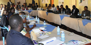
Members of Parliament and LC 5 chairpersons from Karamoja region with officials from the Ministry of Energy and Mineral Development attend a workshop in Moroto District on Monday. PHOTO BY STEPHEN ARIONG
What you need to know:
The ministry says surveying Karamoja minerals would help the government and the leadership in the region to know the type of minerals the region is sitting on.
KARAMOJA.
The Ministry of Energy and Mineral Development has budgeted for $20 million (about Shs50 billion) to enable the department of geological survey and mines to map the minerals in Karamoja region using the airborne geophysical survey.
This was announced on Monday by the principal geologist and mapping officer of the department, Mr Zachary Baguma, during a consultation workshop with Karamoja leaders in Moroto District.

Mr Baguma said an airborne geological survey would help the government and the leadership of Karamoja to know the type of minerals in the region. “We have budgeted $20million and we are sending our requests to World Bank and other donors to help us to support the programme,” he said.
The State Minister for Minerals, Mr Peter Lokeris, said the airborne geophysical survey had not happened in Karamoja due to insecurity. He said the money that government had allocated for conducting the airborne geophysical survey in Karamoja was diverted to fight LRA rebels in northern Uganda.
“Once the government gets the money the programme will start soon and the MPs and local leaders in the region should help government to sensitise the community to support the programme,” Mr Okeris said. However, legislators and district chairpersons in the region raised fears that the airborne geophysical survey might scare away residents from their homes once they see planes nearing the surface.
Mr Micheal Ayepa, the Member of Parliament for Labwor County in Abim District, said the programme is well intentioned but it might prompt people to run away from their homes if they are not availed enough information about the survey.
Mr Abraham Loki, the MP of Jie County in Kotido District appealed to the ministry to earmark a three-to-four month period for educating the locals about the importance of the survey and that the MPs and the district leaders must be involved in the sensitisation.
Airborne geophysical surveys are a widely accepted and cost-effective method for remotely gathering certain types of geological information in several parts of the world.