Lake Nabugabo boundaries expanded to four more districts
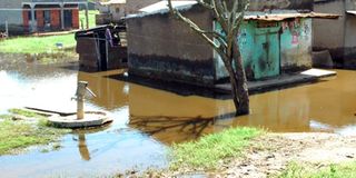
Encroachment. Some of the houses submerged in water on the Nabugabo catchment area in Masaka District. PHOTO BY MARTINS E. SSEKWEYAMA.
What you need to know:
- The new management plan, according to Mr Byaruhanga, has already been assented to by the Ministry of Water and Environment, which has rigorously responded to the emergent threats such as wetland encroachment, draining of swamps and other environmentally unfriendly human activities that are threatening the catchment area.
- Recently, President Museveni said government had embarked on a long term strategy to recover, restore and protect all wetlands in the country.
- Nabugabo Ramsar site is also home to 281 bird species, including 15 per cent of the world’s population of the blue swallow other rare and highly threatened but internationally important plants and animals, including a range of mammals, reptiles, invertebrates and amphibians.
Masaka. In a bid to promote conservation of Lake Nabugabo eco-system and the lake’s catchment area, government, working with environmentalists, has hatched a plan to expand the boundaries of Lake Nabugabo wetland system from the current 22,000 hectares to 777,000.
This is part of a new 10-year conservation management plan for the lake wetland system designed by Nature Uganda, Uganda Wild Life Authority, (UWA) and National Forestry Authority (NFA) to save the lake from depletion.
Lake Nabugabo catchment area connects several rivers and wetlands in Masaka, Gomba, Mpigi and Kalungu districts and drains directly into Lake Victoria.
It is a satellite lake of Lake Victoria, only separated by a sand bar.
It is also an important stop-over point for a number of migratory birds and among the few Ramsar Sites (protected area) in the area due to its rich internationally shared ecological significance.
Explaining the objective behind the initiative, Mr Achilles Byarugaba, the Nature-Uganda executive director, said under the new master plan, Lake Nabugabo catchment area boundaries have been expanded from Masaka to cover other wetlands in the districts of Kalungu, Gomba, Butambala and Mpigi.

A joint taskforce with representatives from Nature Uganda, Ministry of Water and Environment, National Environment Management Authority (Nema) and the Masaka District leadership, among others, has been instituted to oversee the implementation of the plan.
The joint taskforce comprises both technical and political stakeholders in the five districts, who are charged with enforcing conservation regulations in their respective jurisdictions.
“The expansion of the boundaries of this internationally important site is also going to foster an expanded conservation approach to ensuring that the environment around Nabugabo is not abused. The public needs to appreciate that we are holding this treasure not only for Uganda, but for the whole world,” Mr Byaruhanga said during an interview last Friday.
Mr Byaruhanga explained that the new management plan is a culmination of their wide research and a series of consultations and assessments conducted between 2014 and 2016, which ascertained that despite the direct ecological interconnection between Nabugabo catchment area and wetlands in these districts, they were being threatened by the ever increasing environmental degradation happening around.
“As environment conservationists, we established that the Ramsar site is increasingly being abused by several unfriendly human activities, which demanded for an urgent intervention to derive practical solutions to save the ecosystem,” he said.
The new management plan, according to Mr Byaruhanga, has already been assented to by the Ministry of Water and Environment, which has rigorously responded to the emergent threats such as wetland encroachment, draining of swamps and other environmentally unfriendly human activities that are threatening the catchment area.
He added that the plan also has a broader approach of transforming the site into another tourism potential capable of becoming of great economic significance to the country.
The developed strategic conservation plan will be implemented at a cost of $8m (about Shs28.3b) from United States Agency for International Development (Usaid), according to Mr Byaruhanga.
Uganda’s wetlands are under threat and are being invaded, slowly and almost unnoticeable in rural areas, but heavily and very clearly in urban centres.
In rural areas, wetlands have mostly been encroached upon by farmers looking for land for cultivation, while others are engaging in sand mining, which recently became a lucrative business due to the swiftly growing construction sector where it is used to make concrete.
Most of the sand used at construction sites in urban centres, specifically in central region, is excavated from Lwera wetland in Lukaya Town Council, Kalungu District, which is also part of Lake Nabugabo catchment area. Besides using very heavy machinery to excavate sand, companies engaging in this business are digging very deep ditches in pursuit of fine sand, which is also said to be exported to other countries as silica.
Despite a recent directive by Parliament banning sand mining in Lwera, companies and individuals have carried on with the illegal activities in the wetland, which are directly affecting Lake Victoria buffer zone and they are evidently not monitored by any authorities, including local leaders.
However, Masaka District chairperson Jude Mbabaali faulted central government for failing to protect wetlands in the country.
“Government has deliberately failed to protect wetlands since there are many people within its ranks who are benefiting from illegal activities carried out in wetlands. A local leader does nothing since those engaging in sand mining have clearance from powerful people in Kampala,” Mr Mbabaali said.
Recently, environmentalists raised concern over the increasing sand mining in major swamps such as Lwera, warning that excessive excavation of sand will spark off a serious ecological disaster if not controlled.
The Ministry of Environment recently announced that it was in a process of demarcating areas around the country in which sand mining will be permitted.
The move is aimed at ensuring greater protection of the natural ecosystem.
Speaking at the national celebrations to mark World Wetlands Day at Bbulakati playground, Lukaya Town Council in Kalungu District recently, State minister for Environment, Ms Mary Gorreti Kitutu, said her ministry is undertaking several strategic actions to curb wetland degradation as they implement a Cabinet directive on cancellation of titles in wetlands.
Recently, President Museveni said government had embarked on a long term strategy to recover, restore and protect all wetlands in the country.
“I, therefore, urge all Ugandans to embrace this effort and appreciate the value of wetlands for the present and future generations,” the President said.
Wetlands in Uganda cover less than 10 per cent of the land surface area.
However; these wetlands have been on a downward slide from 15. 6 per cent in 1994 to 10.3 per cent in 2015.
Available statistics show that Uganda has lost more than 30 per cent of the wetlands in the last 23 years.
These trends indicate the country’s increased risk and vulnerability to natural disasters and other effects of climate change evident from the prolonged drought currently battering some parts of the country.
About the lake
Ramsar site. Lake Nabugabo was listed as a Ramsar site in 2004 under the authority of Masaka District local government because of its high biodiversity and provision of ecological services.
Its rich biodiversity is defined on its boast to over 300 plant species; 14 of which are not found anywhere else in Uganda.
Habitants. Nabugabo Ramsar site is also home to 281 bird species, including 15 per cent of the world’s population of the blue swallow other rare and highly threatened but internationally important plants and animals, including a range of mammals, reptiles, invertebrates and amphibians.