Migingo row: Fishermen battle for beach unit
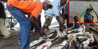
BUMPER: Fish dealers sort their catch at Migingo Island. PHOTOS BY JOSEPH MITI
What you need to know:
Facts box about disputed island
- In 2008-2009 the island itself was claimed by both Kenya and Uganda.
- July 2009 a survey team found that the island is 510 metres (1,670 ft) east of the Kenya-Uganda border within the lake, a finding supported by openly available Google Earth imagery.
- Since 1926, territorial ownership of the island has been consistently shown on maps and in language on official documents as Kenyan.
- However, much if not most of the Ugandan protests revolve around the lucrative fishing rights, mostly for valuable Nile perch, and Ugandan waters come within about 510 metres (1,670 ft) of the island.
- In July 2009 the Ugandan government shifted its official position, stating that while Migingo Island was in fact Kenyan, much of the waters near it were Ugandan.
- The island had been claimed by the Ugandan government in 2008-2009 until 11 May 2009 when Ugandan President Yoweri Museveni conceded that the island is in Kenya, but continued to point out that Kenyan fisherman were illegally fishing in Ugandan waters which lie just a few hundred metres (about 700 ft) to the west of Migingo, the Ugandan flag was lowered, Uganda withdrew its military troops, and agreed that all its police officers would leave the island.
- A joint re-demarcation line of the border was launched on June 2, 2009 to recover and to place survey markers on land, making delineation of the boundary on the lake more precise, with results released in late July 2009 confirming that the island falls 510 metres (1,670 ft) on the Kenyan side of the line.
It is almost one year since the governments of Uganda and Kenya commissioned experts to find out exactly where Migingo Island lies. This same island has been a centre of dispute between fishermen from the two countries. In a twist, as our reporter Joseph Miti finds out, the fishermen are not fighting over ownership of the tiny island but rather over the control of the Beach Management Unit.
For a first time visitor, the approach to the three rocky Islands jutting out of Lake Victoria waters, one of which is Migingo, is breathtaking.
The biggest, looks rather like a gigantic elephant; another takes the form of a pyramid, while the smallest that is just a little above the water line is all covered in corrugated iron. The pyramid-like and the iron sheets-covered islands are only separated by a narrow strip of water.
Migingo Island, the tiniest, is home to about 1,000 people from the three East African states of Uganda, Kenya and Tanzania. It is a popular abode for fishermen because of its flat, rocky beaches which make it easy to dock boats.
When I landed, Mr Willy Godfrey Opio, a Ugandan fisherman who would be my guide, was amused that anybody would think as I did; that the Migingo islanders would squabble to the point of killing each other for this tiny islet.


“I have lived here since 2006, but no one has been killed. The wrangling is between governments but not us the fishermen.” I am still bewildered since these rocky islets that have caused outrage between Uganda and Kenya to the brink of a shooting war, until a Kenyan, Mr Abdu Noor Ahammed, joins our conversation.
Controlling BMU
“The argument is about the control of the Beach Management Unit (BMU); the Kenyans and Ugandans in the leadership want to exclude the other nationality from the benefits of the leadership,” he says.
The 4,000-square-metre (one-acre) island, the size of a football pitch, in proximity to some of the surviving rich deep-water in Lake Victoria, has since 2008 been claimed by both Kenya and Uganda.
Migingo is 5.4 nautical miles (15km) off Kenya’s Muhuru Bay in Nyatike district. From Uganda, it is six-hour drive in a motor boat from the landing point at Namayingo. So the Kenyans cite their closer proximity to the island to imply ownership.
Kenyan President Mwai Kibaki reassured Kenyans on the 48th Madaraka Day in Nairobi that the islands of Migingo and Ugingo squarely lie on Kenyan territory, but added that the Kenya government would not behave in a manner likely to strain the relations between the two East African nations.
Ugandan authorities, however, maintain that the island is within the boundaries of its eastern district of Namayingo and indeed the Google earth map attests to this perception, supported by the 1926 final Kenya-Uganda border demarcation by the British Foreign and Colonial Office.
For over three years, the Kenyan media has been hysterical, sounded war drums and urged their government to claim the island from an imaginary Ugandan occupation, slyly ignoring the geographical coordinates or maps.
When I landed on the Migingo, two local radio stations were announcing that about 42 people had been killed on the island the previous day, but a Uganda police officer who wanted anonymity as he is not authorised to speak for the force, said four prominent Kenyans have taken it upon themselves to regularly pass on false information to local radios, inciting their government to take some action.
“It seems they want their government to seize the island, which will enable them to take over their management,” he said. Mr Gerald Kamya, a Ugandan on the island argues that the boundary lies at the tip of the pyramid (the Kenyans call it Ugingo). The Kenyans too agree that the Pyramid is the boundary but rather prefer to refer to the island as the Pyramid.
A similar argument developed over Wayasi Island also in Lake Victoria, almost leading to a shoot-out, but it was established that the island was indeed in Uganda and Kenya backed off.
Pirates den
Ugandans have been on Migingo since 2004, after migrating from Remba Island, also located along the Uganda-Kenya boarder, citing mistreatment by Kenyan officials managing the latter. Then, there were no occupants on Migingo.
“It was a pirates den…, some, with assault rifles, from Uganda, Kenya and Tanzania would hide here after stealing our boats, engines, nets and fish,” Mr Joseph Nsubuga, the BMU Chairperson, recalls.
He said the fishermen then appealed to their respective governments for help and the Ugandan authorities responded by stationing a Maritime Police detach on the island to protect the fishermen. Mr Nsubuga said Kenya did not respond on grounds that the island was in Uganda.
Discussions
Following several discussions with Kenyan officials, Ms Naava Nabagesera, the Bugiri Resident District Commissioner (RDC) at the time and the Maritime Police Commander, Mr John Jones Ssekiziyivu, persuaded the Ugandan fishermen to settle on the island and give company to Uganda Maritime Police.
It was then that the Ugandans who said were suffering mistreatment relocated to Migingo and were later joined by Tanzanians who landed about 50 boats and lastly the Kenyans who saw an opportunity in this development.
The Ugandan officials on the islet soon realised that a lot of money was being made, hence a tax -development fee - that was introduced. An increasingly harsh regime ensued as entry permits, taxes, fines and ransoms were exacted on the people, leading to the emergence of issues over leadership and money, the genesis of the squabbles on the island.
According to an islander, Mr Peter Kamugisha, most Ugandans on Migingo accuse a fellow Ugandan, Mr Deziderio Kalema, of instigating chaos when he fell out with colleagues.
“Kalema proclaimed that the island was Kenyan, to woo the Kenyans into supporting his candidature as BMU chairman…he produced a map that indicates that the islet belongs to Kenya, from which point the Kenyans took up the issue and claimed the island,” Mr Kamugisha said.
Mr Kalema admits that Ugandans instigated the muddle, but denies knowledge of the contradictory map. “This chaos was started by greedy people who were fighting whoever asked for accountability…when I partnered with the Kenyans to fight injustice; I was misunderstood and branded a traitor,” Mr Kalema said.
The power struggle has, however, shifted from being among the Ugandans, to Kenyans against Ugandans. Kenyan fishermen led by Mr Juma Ombori think if their government takes over the rock, they will take the leadership as well, but the Ugandans are standing firm on their sovereignty.
A report by the firm that was last year contracted to survey and establish the border has not been made public. Some fishermen (both Kenyans and Ugandan), now want their governments to release the findings and end the tension, while others feel it is not necessary since all the inhabitants’ common goal is a conducive atmosphere for business.
Mr Stephen Onyango fears that once the findings are released, it is the Kenyan fishermen to lose. “If the rock is in Kenya, Uganda will bar us (Kenyan) from fishing in their waters.”
Over 20,000 Kenyan boats are estimated to fish in Ugandan territory. Kenya has only six per cent of the lake, Uganda 43 per cent while Tanzania owns 51 per cent. Interestingly, although Kenya has the smallest percentage, its catch doubles Uganda’s.
According to statistics, Uganda exports 22,731 metric tonnes of fish, compared to Kenya’s average of 180,000 metric tonnes annually. Ugandan fishermen believe that once government surrenders the island, insecurity is likely to reemerge since it is the only sole island on Ugandan side where security can be stationed.