A year later, Kasese still grappling with floods menace
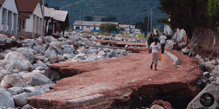
A road that was destroyed by floods in Kasese District in May last year. PHOTO By ABDULAZIZ TUMUSIIME
What you need to know:
Time bomb. Kasese District environment officer says there are indicators that they can be hit by the floods any time given the volumes of water they are experiencing.
KASESE.
It is exactly one year and three months since Kasese District was devastated by flash floods, and the authorities are still unsure of what next as the sky opens up again.
Both local leaders and residents are wondering why government has not bothered to come to their rescue as the rainy season starts this month.
Kasese was hit with two devastating floods on May 1 and 8, 2013, which left close to 20 people dead, others injured while several people were displaced from their homes.
The Kasese District environment officer, Mr Augustine Kooli, is worried that the district may be hit by yet another flood this month, saying it is the beginning of the long rainy season.
“Though we have not contacted the meteorology office to know the amounts of rainfall we are likely to receive this season, there are clear indicators that any time we can be hit by the floods, given the volume of water we are experiencing now,” Kooli said on Wednesday.


More complicated
The environment officer added that issues of floods in Kasese cannot be solved by mere de-silting (removal of soil and waste materials) from the river -- which government has started by putting up gabions (large square containers in which rocks are packed) and retainer walls to control and redirect the water.
“It is true government has released some money for de-silting, but I do not know the amount. But this will not solve our problem. Remember river erosion and deposition is carried out under the normal hydraulic verbosity and gradient is either the same or equal,” Kooli said.
What Kooli means is that the volume and speed of the river is always the same, even if it is de-silted, the river will still carry and deposit objects. He says instead of de-silting the river first, government would have placed gabions so that the boulders removed are put behind them and this would have worked better other than removing soil that will be brought back anytime.
The environment officer advised the government that the issue of human activities alongside the river banks must be tackled seriously if the problem of floods is to be handled at length.
“We need to respect the river banks by stopping all human activities like cultivation, constructions and sand mining which weaken the river,” he said.
A resident of Kilembe valley, Dr John Baluku, told this paper that people in the area have continued to drink contaminated water ever since the pipes collapsed last year during the first floods.
Jetress Kabugho, who lost a brother during the first floods at Kilembe, blamed leaders for not implementing the presidential directive to submit the names of the affected families so that they could be helped.
“It is now a year down the road since our loved ones died in the disaster, but to date no single leader has ever come to us to take the particulars of the affected families and we wonder why,” Kabugho said.
Alex Kwatampora, the project manager Tibet Hima Company Limited, which took over Kilembe Mines Ltd, says they spend more than Shs2 million daily on the de-silting and rechanneling of the river.
Kwatampora said Kilembe Hospital has had some renovations but that the security at the facility is at stake since the fence was washed away and some water still passes some few meters to Toto Ward.
He noted that some temporary bridge was being put up at Kyanjuki that connects Kilembe mines offices with the rest of the area.
However, the Kasese Municipality mayor, Mr Godfrey Kabyanga, says the district needs heavy machines to re-channel River Nyamwamba, otherwise the district could be sitting on a time bomb.
Kasese District has been hit by floods every year for nearly the last five years, leading to loss of lives and property, but the magnitude of the damage caused by the large volumes of water has increased since May 1, 2013.
In May, government said it needed Shs30 billion to de-silt River Nyamwamba to stop the bursting of its banks.
There are several other rivers emanating from the Rwenzori mountain ranges that also burst their banks. And as such, some environmental and hydrological experts say the situation could be experienced for the next two years or so.
“The climate change phenomenon is always after a long period of time like 10 years; by happening last year does not mean that it will not happen again in a subsequent year.
The challenges are expected to be around for two years,” said Jeconious Musingwiire, the western region focal person and public awareness officer for the National Environment Management Authority.
“The challenges are trans-boundary as some come from the Democratic Republic of Congo as the Rwenzori ranges spread far from the Uganda border,” Musingwiire adds.
Solution
Musingwiire says the best solution is to promote integrated water resources management through enhancement of natural vegetation cover by tree planting, restoration of degraded sections of bare grounds and critical river line wetlands, and promotion of soil and water conservation structures in the agricultural fields.
He says there is a need to enforce the environmental laws, especially on observing the regulated area of 30 metres around the river banks to allow the stabilisation of the banks and to allow natural vegetation infiltration and stop the speeding water that eats up the river banks.
“To achieve this, we need to bring all stakeholders on board and allow participatory planning and implementation, especially in the enforcement of laws,” says Musingwiire.
Last week River Nyamwamba had a discourse, destroying blocks at Bulembia School and the head offices of Kilembe Mines Limited.
Currently the river flows along the recently renovated Kyanzuki road, about 100 meters from its original course.
About Mt Rwenzori region
Rivers Nyamwamba, Rwimi, Mobuku, Ssebore, Lhubiriha, Mpanga, Nyamugasani among others, and several streams flow from Mt Rwenzori and most of them empty into Lake George, among other water bodies.
People living on the slopes of the mountain basically practice poor farming methods, thus causing soil erosion and numerous landslides. Deforestation is another major problem facing the mountain ranges.
More than 90 per cent of the communities living on the mountain slopes depend on firewood for fuel, leading to extensive destruction of forests, letting floods in the low lands and global warming as the glaciers have been greatly affected and are disappearing steadily.
Govt approves recovery plan
Cabinet noted the magnitude of destruction that had occurred as a result of heavy rains which caused floods in Kasese District on May 1, 2013, and directed the ministry of Finance to avail funds amounting to Shs39b to facilitate the relocation and resettlement of people in all areas that were highly prone to landslides and floods.
Therefore, the Kasese District Disaster Recovery plan 2014/2015 is a comprehensive response to the recovery needs of the affected areas and surrounding communities by reducing their vulnerability and enhancing their resilience to possible disasters of a similar nature.
The recovery plan also aims at reducing vulnerabilities and enhancing the resilience of the district and its populace. The recovery plan takes cognisance of the prioritised needs of the affected communities arising out of the local consultations.
It will also promote recovery of Kasese after floods, rebuild and promote business, restore people’s livelihoods and build their resilience to disasters and enhance early warning systems.
By Information minister, Rose Namayanja (August 14)