Dokolo: Linking the north to eastern Uganda
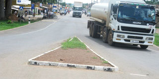
The Soroti-Dokolo-Lira road that serves as a link between eastern Uganda and northern Uganda. PHOTOs by Bill Oketch
Dokolo. The district derives its name from Adag kolo, literally meaning “we don’t want aggression, we are peaceful people.”
Dokolo is a gate way district to the north from the eastern region. It was originally part of Lira District, before it was curved out in 2005 and it became an independent district on August 6, 2006.
Administration
The district has 10 sub-counties of Adeknino, Adok, Agwata, Amwoma, Batta, Dokolo, Kangai, Kwera, Okwalongwen, Okwongodul and one town council; Dokolo. There are 60 parishes/ wards and 474 villages/ cells in the entire district.
Population & size
The population projection as of mid 2013, was estimated at 200,900, according to Uganda Bureau of Statistics. The district population is growing at an estimated annual rate of 3.2 per cent. Life expectancy is 48 years for males and 52 for females, according to Health Management Information System of 2014. The total land area is 1,352 square kilometres, and the land under cultivation is 1,228 Sq km.


Location
Dokolo District is bordered by Lira District to the north-west, Alebtong District to north, Kaberamaido District to the east, Amolatar District to the south; Apac District to the west, and Amuria to the north-east. The administrative headquarter of the district is at Dokolo Town Council, located approximately 58 kilometers, by road, southeast of Lira.
Schools
Dokolo has 85 primary schools, 60 of which are government-aided, 20 are private and five are community schools. It has five government-aided secondary schools and two private ones. The district also has one government-aided technical school and three private ones. It also has 65 nursery schools.
Land ownership
Land disputes among the communities remains a hindrance to development. Most of the land is communally owned and over the years, there has been a rise in land disputes resulting in the halting of a number of activities.
Climate
The rainfall in the area is described as bimodal rainfall pattern with one peaking from April - May and September to October. The hottest months are January, February and December. The area is dominated by tropical savannah woodland with short grasses.
Tourism potential
The district has tourism potential, but has not yet tapped any revenue from tourist resources. The best prospective is the site at Kangai, where Omukama Kabalega of Bunyoro and Kabaka Mwanga of Buganda ,were captured by the British colonialists on April 9, 1899.
However, the site has remained redundant with only two monuments erected in memory of the two kings on a 20 acre-piece of land.The other tourist potential which also remains untapped is the traditional Okoce dance, almost remaining only in Dokolo and Alebtong districts.
Safe water coverage
Almost 88 per cent of the district receives safe and clean water. Most households have access to boreholes in their homes and in the neighbourhood within a radius of one kilometer.
Revenue
The district revenue is mainly from market dues, licensing of business, produce exit tax, local service tax and hotel tax which is limited to the town council; animal movement permit and the charcoal burning and movement permit.