Exploring oil using an eco-friendly system
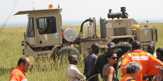
The mini vibrator which produces shockwaves that enable the node to pick up seismic data. Photo by Isaac Imaka.
Before oil production starts, companies carry out a survey of the prospective oil fields to find out whether the resource thereunder is worth the time and money or in the oil industry speak, whether the oil is of commercial value.
Seismic survey is, for instance, when you cut through a cake and you see its inside layers from top to bottom. So when companies carry out the survey, they are able to see the soil layers just the way you see a cut cake.
The same is done during the appraisal period – when after discovering the commercial quantities, companies try to ascertain the length and width of the oil wells to determine the final plan of extraction.


This process has been conventionally done by laying long lines of cable wire along the land under survey, with huge trucks that produce vibration and thousands of field personnel to monitor the cables.
ZLand technology
But in Uganda, a new technology, never used anywhere on the continent, has emerged –the ZLand technology. This is being used by Total E&P in its 3D seismic survey in the Murchison Falls National Game Park.
“We wanted a technology that would be easy to use in a game park without affecting the environment, wildlife and tourism,” Adam Turnbull, Total’s seismic superintendent says.
According to Turnbull, it took a total of 18 months to find the right seismic technology for the activities in the Murchison park, a place regarded by the United Nations as a Ramsar site, with scores of endangered birds and animals.
Total’s field under seismic survey is 405 square-kilometres and 90 per cent of that is within the park.
The objective, Total says, is not just to study the area for the purpose of discovering more oil reservoirs but it is to also leave it in exactly the same condition as they found it.
“We have to be very specific while collecting seismic data. If we are not specific we will waste a lot of money, a lot of effort and time, and put a lot of exposure [to the wild animals] on our work force,” Mr Turnbull explains
How it works
“Cables are used to transmit information from one point to another. Now we are using a unique system that captures all the information in a module,” Turnbull told Oil and Gas journalists during a tour of the Park, “that module is placed in the ground and it’s taken out after a number of days, we then take it to the computer system, download data and we have a look at how it has been recorded.”
The nodal, as it is commonly called, is produced by Fair Field Nodal, an American Company, weighs about 2.7 kilogrammes and costs not less than £3,000 pounds (Shs10m) a piece. Total has 15,000 pieces. It is a passive system with a very low visibility. Given the fact that reducing visibility and movement while working in the park is paramount for the free movement of wildlife, the nodal comes in handy in trying to protect the animals and tourism. The nodal is buried under ground, 16 to 20 centimetres deep and depends on miniscule acoustic shockwaves in the ground produced by a mini vibrator.
The mini-vibrator moves the ground at a certain frequency for a certain length of time and eventually, reflections come off the different strata below the surface and Total’s seismic engineers measure the waves back on the ground. That gives a geological map after processing the data using high-powered computers.
Once the data is processed, an image that looks like a cake sliced in half comes up and you are able to see the layers of the ground below.
Works on both land and water
On the base of the nodal is a spike that is placed into the ground to keep it firm and ensure that there is a pure seismic signal without any noise. It has a battery whose longevity when fully charged is between two to four weeks.
Because it is buried, it is tracked using GPS that also helps the engineers to get accurate timing.
It also has a Geophone that helps pick out vibrations from manmade movements or the other animals.
The units are positioned 12 and half metres apart and can also be used offshore, although the housing there is different to enable it to float. With the right housing, it can work 3,000 metres deep in water and can be left there for six months and through a command you can pop it up above water.
The disadvantage of the technology is that it can easily be lost. “When you lose it, you lose data,” Turnbull says. “Baboons also love kicking them as toys if you don’t bury them deep enough.”