The plan that gave birth to Uganda’s road network
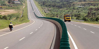
The Kampala-Entebbe Expressway. FILE PHOTO
What you need to know:
- First roads. In 1946, a 10-year Uganda Development Plan outlining the future of roads in the colony was formulated. The first trunk roads that were considered for bitumen were the Kampala-Entebbe, Jinja-Iganga, Kampala–Jinja, Kampala-Masaka, Kampala-Bombo and Kampala- Mubende.
What we now know as ministries were departments during the colonial days. Almost 58 years after independence, the ministries that replaced departments have some of their mandate taken over by parastatals. They are equivalent to the departments of the olden days.
The Public Works Department of the colonial days was synonymous with roads. Today, Uganda National Roads Authority (UNRA) is what Public Works Department was to the colonialist.
Under colonial rule, roads in Uganda were divided into two categories. There were the national roads under Public Works Department and the secondary roads under the Native Administration, now known as Local Government.
The two were responsible for the construction and maintenance of roads countrywide. This may sound much similar to the present situation.
In 1946, a 10-year Uganda Development Plan outlining the future of roads in the colony was formulated.
According to the plan, the cost of constructing one mile of a national road at the time was £1,000 (Shs200,000) that is equivalent to £42,157 today, or Shs190 million at current exchange rate.


The report stated that bitumen surfacing of the road would cost £750 (£31,618 or Shs142m today) per mile.
As though reading the minds and attitude of Uganda’s future generation, the author of the report, EB Worthington, cautioned against massive bitumen surfacing of roads.
“It appears more desirable to surface with bitumen a large mileage of the roads on the present alignment, slightly improved by evening out serious bends and corners than to devote money and effort to drastic alternations of which the chief advantage will be speed,” Worthington writes.
Being conscious of the effects of speed, Worthington was of the view that more roads be constructed to be all-weather, and carrying cars with speeds not exceeding 50m/h (80kms/h) and lorries not beyond 35m/h or 56kms/h).
Entebbe has not only been prioritised in the present day, but even during colonial times. Access to Entebbe Town was a concern to the authorities.
“The Entebbe–Kampala road is exceptional in that it requires extensive re-alignment because of its vital function in administration and as a link between the commercial capital and the main aerodrome (airport),” the report reads in part.
The use of bitumen in road construction at the time was based on the volumes and axles of the cars plying that particular road.
Besides certain roads that were considered important, those that recorded a density of 70 cars and more a day were considered for being widened and upgraded to bitumen. The rest were to be upgraded to gravel level and await for bitumen when the need arose.
The first trunk roads that were considered for bitumen were the Kampala-Entebbe, Jinja-Iganga, Kampala–Jinja, Kampala-Masaka, Kampala-Bombo and Kampala- Mubende.
The six roads had a combined mileage of 278 miles, or 447.3kms, at a cost of £355,500 or Shs18m at the time. Today it would be an equivalent of £15m or Shs68b.
Besides the six prioritised roads, the development report considered another 1,500 miles to be considered for upgrading to gravel across the country.
The development plan also factored in the maintenance of the constructed roads. Maintenance camps were proposed on all major roads every 50 miles (80kms).
“Each depot will provide accommodation for an itinerant inspector, an overseer, four family dwellings for regular employees, dormitory for temporary labour, a canteen, and other amenities,” the report says.
The future
The plan also drew up future road networks that were to be developed by the Public Works Department. Each proposed road had its justification.
Among the roads included the Fort Portal-Ndaiga road. It was to terminate at the Ndaiga Bay at the southern end of Lake Albert.
According to the report, the road was considered for carrying copper from Kilembe to Kenya. At Ndaiga Bay, copper would to be carried by the East African Railways and Harbours Services.
“This Ndaiga road will have a number of advantages, it will reduce by many miles the road haul from the productive Tooro to Kenya and Uganda Railways and Harbours Transport System. Some of this produce, which ultimately travels north to the Sudan, would be able to proceed direct by water from Ndaiga to Nimule instead of taking a much longer route overland,” reads the report.
Kampala-Gulu road was proposed in the 1946 development plan to cut short the distance and time it took for one to travel from the two destinations.
The old route required one to travel from Kampala through Hoima to Masindi and connect to Atura Ferry before continuing up north to Gulu.
“There are two possibilities, both using the existing route from Kampala to Bombo, both involving a bridge over Kafu River near Kibangya,” the plan stated about the Kampala-Gulu road.
The proposed route through Bombo was to reduce the journey to Gulu by 60 miles, or 96kms.
The road from Tororo to Bugiri was proposed once the ‘north road’ in Kenya, which was to link with the Ugandan systems in Tororo, was complete. This was part of the inter-territorial transport network the colonial authorities had in plan to link East Africa. The other network was the railways and harbours.
According to the plan, the inter-territorial connection to Uganda was to go through Tororo and not through Busia.
“It will probably be desirable to construct a new link from Tororo to Bugiri and it would save 25 miles on the route from Tororo to Jinja,” the report reads.
Kilembe to Mbarara
The new Kilembe-Mbarara road was meant to accelerate the development of the Kiembe copper deposits ahead of the railway line.
The new road was also to ease transport between the new proposed western province headquarters which were to be relocated from Bunyoro to Fort Portal. The new western province covered the kingdoms of Bunyoro, Ankole, Tooro and the Kigezi.
Just as UNRA has established different ferries to ease water transport today, the colonial government also appreciated the use of the vessels.
The plan included the establishment of motorised ferries to replace the ones that were in operation that were either manually operated or moved using paddles. The old system was blamed for the delay on many of the waterways in the country.

First roads. A photo showing Kampala in its early years. Almost all the first major roads constructed by the colonial government were from Kampala, spreading out to the other regions. FILE PHOTO
Three main ferries were to be introduced. One was to be at Tirinyi to cross the Mpologoma River. The other was to be at Atura on the Victoria Nile on the road from Masindi to Gulu and the third was to be at the proposed road from Kilembe to Mbarara.
Native Administration roads
The Native, or Local Administration as it is called today, was responsible for inter-district roads. These were to link different districts in the provinces. In the Northern Province, roads proposed included the Gulu-Pakwach road.
This road was needed for a number of reasons according to the report.
“Capital investment would almost certainly be justified by the saving of mileage and time of government officials and traders when travelling to Arua. And thereby easing administration of the province and the supervision of the sleeping sickness in the area east of the Albert Nile,” the report says.
Masindi-Pakwach road was to start from where the road from Gulu stopped in Pakwach.
“When the road from Gulu to Pakwach is completed, it will connect southwards to the Bunyoro system near Masindi by a route through the game reserve and crossing the Nile at or near the Murchison Falls. This road will be useful for inter-district communication and will also have a high tourist attraction.”
This forms part of the present day oil roads.
About the costs
According to the plan, the cost of constructing one mile of a national road at the time was £1,000 (Shs200,000) that is equivalent to £42,157 today, or Shs190 million at current exchange rate. The report stated that Bitumen surfacing of the road would cost £750 (£31,618 or Shs142m today) per mile.