Why Ntoroko suffers the worst of both dry, wet seasons
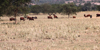
Cattle feed on dry grass during the dry season in Butungama Parish, Rwebisengo Sub-county in Ntoroko District in 2012. The district is a cattle corridor. PHOTO /FELIX BASIIME
What you need to know:
- With funding from the African Development Bank, the Ministry of Water started a project of restoration of catchment areas of Lake Albert and Lake Edward.
- In order for the residents of the district to improve the way things are, Mr Masereka suggests that people should be discouraged from staying in the low land areas of Karugutu Sub-county.
On May 10, Ms Jessica Kobugabe, 62, was seen erecting a temporary shelter under a tree shade in Kachwakumu Village, Kanara Sub-county, Ntoroko District.
This was after her house located about one kilometre from the Lake Albert shoreline was submerged in floods as the water volumes in Lake Albert rose.
Ms Kobugabe said the floods displaced her and household property. To access her submerged house, one had to use a boat.
“I don’t know why we people of Ntoroko District suffer every year. This time of the rainy season people are displaced by floods. Someone has given me this place to put a temporary shelter for one week as I look for another place,” she said.
Ms Kobugabe’s story is similar to that of thousands of residents who have suffered similar problems.
From January this year, the rising water levels on Lake Albert in Ntoroko left 3,490 people from 914 homes displaced, according to Mr Ben Muthahinga, the acting district chairperson. The floods affected villages of Kachwankumu, Kamunga, Kataga, Kyapa, Masaka and Butugama, all in Kanara Sub-county.
The displaced residents are still being sheltered in churches and schools while others migrated to nearby sub-counties that were not affected by floods.
This has been a recurring story in this area. In 2012, River Semliki burst its banks due to heavy rains, leaving about 500 people displaced. The river did the same in 2014, leaving at least 500 people homeless, and in 2019, floods hit Kanara Town Council, leaving one person dead and about 200 homeless.
Ironically, after the rain seasons are over and the dry seasons set in, this very area experiences very dry periods. Mr Julius Rusoke, the Rwebisengo Sub-county councilor, says the dry seasons are the worst for cattle keepers as their cows die in large numbers because of lack of water and pasture. The only source of water during this time is River Semliki, and cattle keepers who live far from it suffer a lot since most of the water points are dry, the chairperson of Butuku Cattle Marketing Cooperative Association in Rwebisengo, Mr Charles Kasoro, says. Even when people try to dig wells and dams, they dry up because the water table is low.

In the dry season of 2018, about 5,000 cows died in Rwebisengo due to lack of water and pasture, the sub-county chairperson, Mr Christopher Adyeba, says. “A cattle keeper can lose about 50 cows in a season. Even our people who are not cattle keepers suffer as they fail to access water for domestic use; people walk more than 10 kilometres to get water,” he laments, adding that the dry season lasts for more than four months.

A side view of the escarpment in Ntoroko District. PHOTO /ALEX ASHABA
The paradox explained
Every year, Ntoroko, whose population stood at 67,005 as per the last national census held in 2014, experiences the worst of the two seasons – both rain and dry seasons. To understand this irony, one must first consider the location and makeup of the area.
Located in western Uganda in the Rwenzori Sub-region, Ntoroko sits below Lake Albert. It borders Hoima District to the northeast, Kibaale District to the East, Kabarole District to the south and Bundibugyo District to the southwest. The district is located in the western rift valley, and has steep slopes that start from Kabarole after Kichwamba Sub-county going up to Bundibugyo District.
Some parts of the district are covered by Tooro Semiliki Wildlife Reserve, a protected area established in 1929. The protected area covers 542 km2.
According to Mr Gideon Masereka a geographer, the northern part of Ntoroko has an escarpment (a long steep slope) that comes from Kichwamba side of Kabarole up to Bundibugyo. From then on, you have the lower land from Kichwamba up to Lake Albert, which is where Ntoroko lies as a flat land.
The geographer explains that during the wet season, rivers in the Mount Rwenzori range, which Ntoroko is close to, are always in the youthful stage when it rains. They keep rising and flowing with a lot of water. By the time they reach the low lands of Ntoroko, they are in an old stage that ends up causing floods.
“At times it does not rain in Ntoroko District but because Mount Rwenzori ranges are near the area, when it rains in the mountains, we just see floods coming,” Mr Ibrahim Baluku a resident said.
The rains, when they come, also leave small rivers such as R. Wasa, R. Itojo, R. Dorwa and several smaller streams such as Kithoma, Kamayatya, Nyangilika, Kanyamabale, Ngisia flooded.
Apart from the location, the soils in the area do not help matters. Senior hydrogeologist Brian Guma of Albert Water Management Zone says: “During western rift valley formation, there was deposition where the soils in the most parts of the low land had clay soil, which does not absorb water during the rainy season. This makes water flood on the land surface.”
In addition, during the rainy season, River Semliki bursts its banks and flooded water from elsewhere takes a while to be absorbed by the river.
Floods at times are also caused by the increase of water levels in Lake Albert, which borders with Ntoroko on the DR Congo side.
The paradox, however, is that the area is not able to keep or contain this water and later experiences a long dry spell.
The reason the district experiences a lot of heat both day and night, and a prolonged dry spell, Mr Masereka says, is because it is on the leeward side of Mount Rwenzori. The leeward side of a mountain receives a warm climate because by the time winds have come from the other side of the mountain, and reached the summit, they hardly have any more moisture, making them dry as they go downward on the leeward side.
Mr Masereka adds that most winds coming from the DR Congo side passing through the escarpment side of Ntoroko are always dry winds, which cannot form rainfall.
“That is why this area has dry vegetation cover because the winds we get from DR Congo don’t form convectional rainfall,” he says.

Cattle using water troughs constructed by the Ministry of water and NRDI during restoration of R. Semuliki. Photo by ALEX ASHABA
Also, the people in the area are predominantly cattle keepers. Mr Chris Amanyire of Natural Resource Defense Initiative (NRDI, says the district falls in the cattle corridor. Only Karugutu and Nombe sub-counties as well as Karugutu Town Council do farming on a small scale. Because people have kept cattle on a large scale over the years, Mr Amanyire says their animals have destroyed the vegetation cover and so during the dry season most places are dry and pressure on land for pasture increases. The huge amount of animals have not spared the river either. “The cattle keepers’ main source of water during the dry season over the years has been River Semliki. Because of congestion of cattle on Semliki, they have destabilised its banks and cause soil erosion,” he explains.
The few available wetlands in the district are also seasonal and during the dry season dry up, leaving a few options for water sources.
Things have worsened from the past
Mr Ibrahim Mpabisi, 65, a resident of Nyabuhuru Village in Karugutu Town Council, says during the 1960s, the area did not experience dry spells as happens today. He says in 1990, population pressure on land increased as people started invading Tooro Semiliki Wildlife Reserve and destroyed trees for charcoal burning thus losing vegetation cover.
“We used to have our season for planting and harvesting and all these changed; in June to July, we could have rain but now it’s a dry spell,” Mr Mpabisi says.
He also says in Nyabuhuru Village, they used to have two water points at Bukojo and Nyabuhuru that would not dry up, even during the dry spell unlike today.
Mr Mpabisi reveals that flooding used to happen but the damage was less compared to today because many people have invaded lake shores where water used to go and set up buildings there.

Way forward
In order for the residents of the district to improve the way things are, Mr Masereka suggests that people should be discouraged from staying in the low land areas of Karugutu Sub-county.
“My advice is that the government should discourage people from settling in the lower land areas because when it rains, most parts get flooded and people’s properties get destroyed. Also, pastoralists should minimise the number of cattle to avoid overgrazing,” he advises.
The residents must also find a way to save the water that comes in abundance, when it floods. Mr Guma says that there is need to have many valley dams in the area to tap flooding water during the rainy season which can be used during the dry season for both cattle keepers and residents for domestic use. Indeed, President Museveni, while visiting Ntoroko District last year, pledged that the government would build valley dams to help the cattle keepers during the dry spell, but Mr Muthahinga says they are still waiting for the pledge to be fulfilled.
However, other projects have been in the works. The Ministry of Water and Environment under Albert Water Management Zone from 2015 started implementing a catchment management plan on River Semliki to stabilise its banks. The ministry and NRDI in 2018 started planting bamboo and other indigenous trees along the river’s banks. They have also fenced off about 30 metres from River Semliki. All this is to stop the cattle and pastoralists from coming to the banks. To help the cattle keepers, they have pumped water from the river for animals, a distance of eight kilometres away from the river.
The chairperson of Ntoroko Citizen Concern, Mr Moses Balinda, says in 2018 they planted 20 million trees in the entire district but unfortunately some dried. They are hopeful, however, that the rest will help in building the vegetation cover.
In addition to those efforts, the Ministry of Water last year embarked on a community project of extending water to benefit the residents of Kanara Town Council and Kanara Sub-county. Its first phase has been completed. According to Mr Muthahinga, the water project will cost Shs83 billion; the first phase consumed Shs25 billion. Once complete residents will able to get water from taps at a small fee (to help with the maintenance).
The national coordinator of the Integrated Fisheries and Water Resources Management project, Mr Steven Ogwete, says the best alternative is to construct flood management infrastructure in all areas that are prone to flooding. “Most swamps in the district have been destroyed and what is needed is to reclaim those degraded swamps because they play a big role in holding water, so that during dry season the place will not dry,” Mr Ogwete says.
Restoration efforts
With funding from the African Development Bank, the Ministry of Water started a project of restoration of catchment areas of Lake Albert and Lake Edward. Catchment areas for restoration, including Semliki in Ntoroko, Tokwe in Bundibugyo and Sebwe in Kasese District, were identified and the team is fencing off swamp areas to avoid human settlement there so that the area can regain its former nature. What is clear in the end is that while Ntoroko’s natural terrain makes it prone to flooding and very dry spells, human activity has worsened the situation. And in order for normalcy to return, the people will have to change their ways to preserve their life and property.