Masaka halts activities on wetlands, to cancel titles
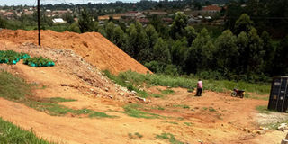
Degraded. A section of Nakayiba Swamp in Nyendo Town, Masaka District, which a private developer has filled with murrum in preparation for construction of permanent structures. Most wetlands in the area are encroached for human activities. PHOTO BY IVAN KIMBOWA.
What you need to know:
Action time. The authorities are also set to evict people who encroached on the wetlands.
In a bid to restore depleted wetlands in Masaka Municipality, authorities have halted all activities taking place on them.
The next step, according to municipal leaders, will be to cancel all land titles developers acquired in wetlands and evicting those carrying out activities in the water catchment areas.
The most depleted wetlands include Nakayiba in Nyendo, a Masaka Town suburb and Nabajjuzi on the Masaka-Mbarara Highway.
Nakayiba wetland forms part of Nabajjuzi wetland system, which is a tributary of Katonga River basin that drains into Lake Victoria.

Nabajjuzi, where National Water and Sewerage Corporation draws water it supplies in Masaka Town, is also a protected Ramsar Site due to its importance for people and animals. A Ramsar Site is a wetland site designated to be of international importance under the Ramsar Convention.
Heath risk
Nakayiba wetland is also being polluted by wastes from car garages around Nyendo Town.
A 2007 UN Habitat showed that crops grown in polluted wetlands pose a health threat to the consumers.
Encroachers on both wetlands have built houses, as well as grown crops such as sugarcane, sweet potatoes and yams on the land.
In August, private developers had started filling soil in Nakayiba wetland, but were stopped by Masaka District chairperson Jude Mbabaali, who questioned how they acquired plots in a wetland.
“We cannot destroy their [developers] properties since they own land titles, but we are in touch with the new district land board to pursue the cancellation of their titles in the catchment area, then we shall restore the area and also change the municipality plan,” Mr Godfrey Kayemba Afaayo, the Masaka mayor, said in an interview on Monday.
He revealed that at least 20 land titles would be cancelled.
Mr Kayemba added that car washing bays, fuel stations and industries constructed in wetlands will be closed.
Masaka Municipal planner Martin Kigozi said they had asked some developers whose plots are not within Nakayiba wetland, but bordering natural resource to erect a retaining wall to block soil from running into the wetland, but they refused to comply.
One of the owners of plots in Nakayiba wetland, who only identified himself as Edward declined to comment on the matter, referring Daily Monitor to National Environment Management Authority (Nema).
During a stakeholders’ meeting between Nema officials and district leaders from Masaka sub-region last month, local leaders accused officers from Nema of allowing companies and powerful individuals to destroy wetlands in the area.
Mr Mbabaali said all their efforts to save the remaining wetlands in their areas have been frustrated by Nema officials.
Mr Mbabaali cited several wetlands which have been destroyed as result of sand mining and another wetland around Lake Birinzi, a satellite of Lake Victoria in Masaka District, which is being claimed by an individual.
However, Dr Jerome Ssebadduka Lugumira, the Nema natural resources manager in charge of soils and land use, said sand mining companies whose licences were renewed follow the guidelines issued by Nema.
He said their research had revealed that sand mining causes no danger to the environment once the miners strictly follow the guidelines.
State of wetlands
Depletion. Ministry of Environment statistics show that Uganda has lost more than 30 per cent of the wetlands in the last 23 years.
The law. Section 36 of the National Environment Act provides for the protection of wetlands and prohibits reclamation, erection of illegal structures and empowers authorities to demolish any structure that is fixed in, on, under or above any wetland. The Act also empowers districts to manage wetlands within their jurisdictions and ensure that their boundaries are clearly demarcated so that even as water levels and wetland vegetation recedes, the communities are clear on where the boundaries lie.