Locals move to restore degraded river banks
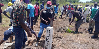
Residents plant concrete pillars and trees on River Adungo banks at the Kapelebyong-Amuria border last Thursday. PHOTO | BILL OKETCH
What you need to know:
- Last Thursday, members of the community were provided with inputs, including bamboo shoots, wheelbarrows, gumboots, hand hoes and machetes, to restore the degraded River Adungo.
Last Thursday, several youth carried concrete pillars while elderly men dug holes at the boundary between Kapelebyong and Amuria districts to restore a river that has been severely degraded.
Women offloaded bamboo shoots from a pickup truck parked by the roadside.
Both the pillars and the trees were then planted at the boundary, which is separated by River Adungo.
River Adungo was previously surrounded by a forest on which about 4,200 residents depended for food, water, and firewood.
However, today it is one of the three river systems in the area that have been severely degraded by the community. Others are River Olupe Opong in Agago and River Karikilet Lokokwayi Kadukuye in Orom Sub-county, Kitgum District.
A recent assessment conducted by Divine Waters Uganda, an NGO, blamed the problem on over cultivation, deforestation, bush burning, sand mining and overgrazing, among other activities.

Last Thursday, members of the community were provided with inputs, including bamboo shoots, wheelbarrows, gumboots, hand hoes and machetes, to restore the degraded River Adungo.
This was part of the activities of a project dubbed ‘Enhancing Resilience of Communities to Climate Change through Catchment Based Integrated Management of Water and Related Resources in Uganda (EURECCCA).’
The government received funding from the Adaptation Fund through Sahara and Sahel Observatory for its implementation.
Under the intervention, revolving funds and inputs are given to communities to demarcate and restore degraded wetlands and riverbanks using markers and concrete pillars.
Mr Richard Musota, the manager of Upper Nile Water Management Zone at the Ministry of Water and Environment, said the government is working in three sub-catchments with a total land size of about 9,000 square kilometres. For the Adungo River alone, a stretch of 16 kilometres on either side of the river system will be demarcated.
After the communities have restored the degraded riverbanks, the Ministry of Water and Environment will form them into groups. “And these groups are supposed to form what we call a water and environment cooperative for Adungo River system. This is the channel through which the revolving fund would be wired,” Mr Musota said.