KCCA develops master plan to curb city flooding
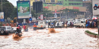
A flooded section of Entebbe Road near Clock Tower. Flooding is one of the challenges city authorities are grappling with. FILE PHOTO
KAMPALA- Whenever the heavens open, Kampala City grounds to a halt as a result of flooding. The water volumes increase, turning a small stream of water into flash floods that sweep everything in its path downstream, causing disruptions and destruction.
Several city shops close, the traffic gridlock intensifies, houses especially in the city slums are washed away, others are submerged in water and sometimes lives are lost as a result of drowning.
With encroachment on the city’s water catchment areas such as wetlands and green spaces by developers, flooding has become inevitable.
The existing drainage channels in the city has not helped either because some of it does not have the capacity to carry the big volumes of water.


Flooding is one of the challenges city authorities are grappling with and majority of people blame it on the poor city physical planning.
Kampala Capital City Authority (KCCA) is now updating the city’s drainage master plan to try to combat the situation.
The plan which was updated in 2017 is expected to be tabled before the KCCA council before it is implemented.
According to KCCA, the aim of updating the 2003 drainage master plan was to develop a fresh solution for storm water drainage in the city that reflects the current socio-economic and drainage challenges.
One of the objectives of the 2003 drainage master plan was to construct tributaries into Nakivubo drainage channel.
However, with increased developments and some changes in the city’s physical planning, the plan outlived its usefulness.
Causes of flooding
Kampala’s drainage is mainly through eight primary channels. These include: Lubigi, Nakivubo, Kinawataka, Nalukolongo, Kansanga and Ggaba, Mayanja/Kaliddubi, Nakelere/Nalubaga, and Walufumbe and Mayanja North. These are served by numerous secondary and tertiary systems.
But human settlements and industrial development have since extended from the many hills to the lower lying areas on the banks of the drainage channels, which are part of wetlands.
Dr Micheal Kiiza, KCCA’s manager for drainages, says the updated master plan is aimed at integrating flood and water quality management.
“Other objectives of the plan are to integrate natural environment, system drainage, infrastructure development control issues and overall planning issues into a cohesive city-wide strategy for drainage development that minimises the impacts of flooding,” he says.
Dr Kiiza adds that the stages in preparing the master plan included, among others socio-economic analysis, status of the drainage system, proposed flood mitigation interventions, structural interventions and non-structural interventions.
“For instance the plan involved assessing the socio-economic conditions of households living in the areas adjacent to the primary and secondary drainage channels, and identifying the drivers and impact associated with storm water management and drainage condition in the city,” he said.
Currently, the frequency of flooding has increased due to increased runoff caused by land-use changes in the catchment areas and reduction of the buffer capacity of wetlands due to encroachment.
Although developers ought to ensure compliance with the physical planning laws, sources at KCCA say they are unable to prosecute those who violate the rules because some of them are influential people in government.
“But even then, we can’t supervise the whole city and some developers erect structures during night hours. By the time we learn of it, buildings are up hence demolishing them becomes an uphill task as such people will use all systems to fail us,” a source says.
Further still, the surging urban population is a big challenge to the city authority’s effort to mitigate flooding.
For instance statistics from the 2014 National Population Census show that Kampala has a day population of 4.5 million and a resident population of 1.5 million people.
However, 60 per cent of them reside in city slums, among which are catchment areas.
And when it rains, the water which would have been absorbed by the catchment areas makes a backflow and starts flooding.
Garbage disposal is poor in such areas. Many slum residents dump garbage in drainage channels because they do not have money to pay for collection of waste.
Under the engineering budget, KCCA will construct and improve roads in the city and also improve the drainage system to mitigate occasional flooding.
Dr Kiiza says KCCA has successfully managed to maintain 165km of drainage channels in Kampala by using both manual and mechanised methods.
The maintenance works, Dr Kiiza says, include dredging, widening and silt removal from drains and site.
The KCCA director of engineering and technical services, Mr Andrew Kitaka, told Daily Monitor that the upgrade of the channels had stalled because there was no study on which KCCA would base to commence the works.
“Now that the study is ready, we are ready to start construction works. However, this will be done after we have officially unveiled the study because the upgrade has to be in line with the current road projects,” he said.
Expert’s view
Dr Amin Tamale Kiggundu, a senior lecturer of planning and urban development at Makerere University, says flooding is linked to climate change and changing weather patterns.
But he attributes flooding in the city to most settlements that have been established in areas that were once wetlands or swamps.
To mitigate this problem, Dr Kiggundu says Kampala needs a good storm water management system which should focus on preserving critical green spaces such as Centenary Park, protecting the wetlands from encroachment and fostering plans aimed at harvesting rain water.
But planners and some KCCA officials say the new Kampala drainage master plan can only be successful when there is enough funding, and compliance with the law by the developers.
Proposed strategies
-Rain water harvesting.
-Permeable surfaces to enable runoff of water.
-Rain Gardens.
-Green Parks and open gardens.
-Filter strips: vegetated (usually grassy).
-Bio-retention areas (Landscaped shallow depressions)
-Detention ponds.
-Retention basins and associated wetlands.