Tracing the route of Uganda’s crude oil pipeline
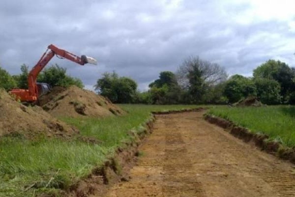
Top soil removal on the crude oil pipeline right of way during pipeline construction. The EACOP is not yet being constructed. URN PHOTO
What you need to know:
The total length of the pipeline is 1,445 Kilometers through 148 Villages in 24 sub counties in nine districts of Hoima, Kakumiro, Kyankwanzi, Mubende, Gomba, Sembabule, Lwengo, Kyotera, Rakai, Kikuube), and 25 sub-counties. In Tanzania, it will cover a distance of 1,147km, through the 8 regions (Kagera, Geita, Shinyanga, Tabora, Singida, Dodoma, Manyara, Tanga) and 24 districts.
Uganda’s waxy crude oil will begin its electrically heated journey to the international market from a pumping station in Hoima district via Tanzanian Port of Tanga.
The pipeline, which will originate from the future Industrial Park in Kabaale in Hoima District, will snake its way through different communities for a distance of 296km as it approaches the Tanzanian border.
At the Industrial Park, the crude oil will be fed into the pipeline through Pumping Station One (PS1), having arrived there via various feeder pipelines from the Well Pads (Oil Wells) dispersed in the Albertine Graben. 34 of the 52 Well Pads are found in Murchison Falls National Park.


In this article, we trace the route of the pipeline from Hoima’s Pumping Station to the border of Tanzania as outlined in the East Africa Crude Oil Pipeline Environment and Impact Assessment Report 2019.
The report says the pipeline crosses relatively low terrain with undulating topography characterised by widespread cropland, settlement and transport infrastructure between Hoima and Mubende districts at the extreme ends towards Tanzania.
Its pathway is technically known as the Right of Way (RoW). It will also traverse gently undulating grass and farmland, hills with open plateaus, open grassland, wetlands in Gomba and Ssembabule districts and a relatively flat landscape towards Mutukula near the border with Tanzania. Inside Tanzania, the Pipeline will host four other pumping stations.
From Hoima District, the corridor passes in between Wambabya and Bugoma Forest Reserves through a modified section of Taala Forest Reserve in Kyankwanzi District, heading in the South eastern direction near the eastern border of Kasana-Kasambya Forest Reserve in Mubende District.
The pipeline will encounter several watercourse crossings including the Kafu River between Hoima and Kakumiro districts, Nabakazi River between Mubende and Gomba districts, Katonga River between Gomba and Ssembabule districts, and Kibale and Jemakunya rivers in Kyotera District.
For approximately 90 kilometres, the right of way corridor crosses a substantial zone of wetlands as it approaches the border of Tanzania through the north-western corner of Lake Victoria.
The EASIA report says “the area is a high average rainfall zone characterized by almost unbroken crop land, whose substantial proportion is under rice cultivation, cattle grazing land and settlement” and that the population occupying the area will be displaced by the pipeline.
The area is home to a broad ridgeline that defines a watershed for the many watercourses and wetlands forming part of the Lake Victoria basin. The corridor nearly clips an abandoned airfield in Kyotera District as well as the former Sango Bay refugee camp close to the Tanzania border.
It then avoids the large local settlement of Mutukula at the border as it progresses into Tanzania. It will be equipped with two Pumping Stations (PS1 and PS2) located inside Kabaale Industrial Park in Hoima and 186 kilometres from the Hoima Pumping Station respectively.
“The Pumping Stations will be self-contained and independent of any locally supplied electricity, water, and waste or sanitary treatment (with the Tilenga Project Central Processing Facility acting as the power generation centre for distributing the required power to PS1 and PS2),” the report states.
Each Pumping Station will be equipped with electrically powered pumps capable of driving the 216,000 barrels of Oil a day flow rate joined to heating substations located a distance of 50–60 km between each electric substation. Along the entire route, there will be only seven electric substations associated with the Uganda EACOP project, two embedded in the foot print of the two Pumping Stations.
On each given day, the pipeline will need to be kept heated at 50 degrees centigrade for its Uganda's waxy Crude Oil to keep flowing. The pipeline will not be visible. It will be buried at a depth of 1.8 – 2 meters.
"It will be buried deeper in areas where it has to cross rivers or roads. The only elements of the pipeline infrastructure that will be visible will be the pumping stations, the electrical heat tracing stations, the block valve stations, the marine storage terminal and offloading facilities." These are known as Above Ground Installations (AGIs).
Mr Christopher Ocowum, the Public Relations Officer of Total Exploration and Production said the pathway will host 19 intermediate block valves comprising of 15 standalones and four co-located valves with electric substations and electric heat trace substations.
He said the pipeline will avoid environmentally sensitive areas such as the Murchison Falls Delta and Rivers using Horizontal Directional Drilling in which the Pipeline will be submerged under the river bed. He says the drilling is done in such a way that disturbance is minimized on the ecosystem above the Pipeline.
The total length of the Pipeline is 1,445 Kilometers through 148 Villages in 24 sub counties in nine districts of Hoima, Kakumiro, Kyankwanzi, Mubende, Gomba, Sembabule, Lwengo, Kyotera, Rakai, Kikuube), and 25 sub-counties. In Tanzania, it will cover a distance of 1,147km, through the 8 regions (Kagera, Geita, Shinyanga, Tabora, Singida, Dodoma, Manyara, Tanga) and 24 districts.
Tullow Oil, Total Exploration and Production, China National Offshore Oil Company (CNOOC), governments of Uganda and that of Tanzania are expected to take the final Investment decisions on the development of the Pipeline when NEMA approves its Environment and Social Impact Assessment (ESIA) report.