Anger, despair as govt abandons Ntoroko flooding victims
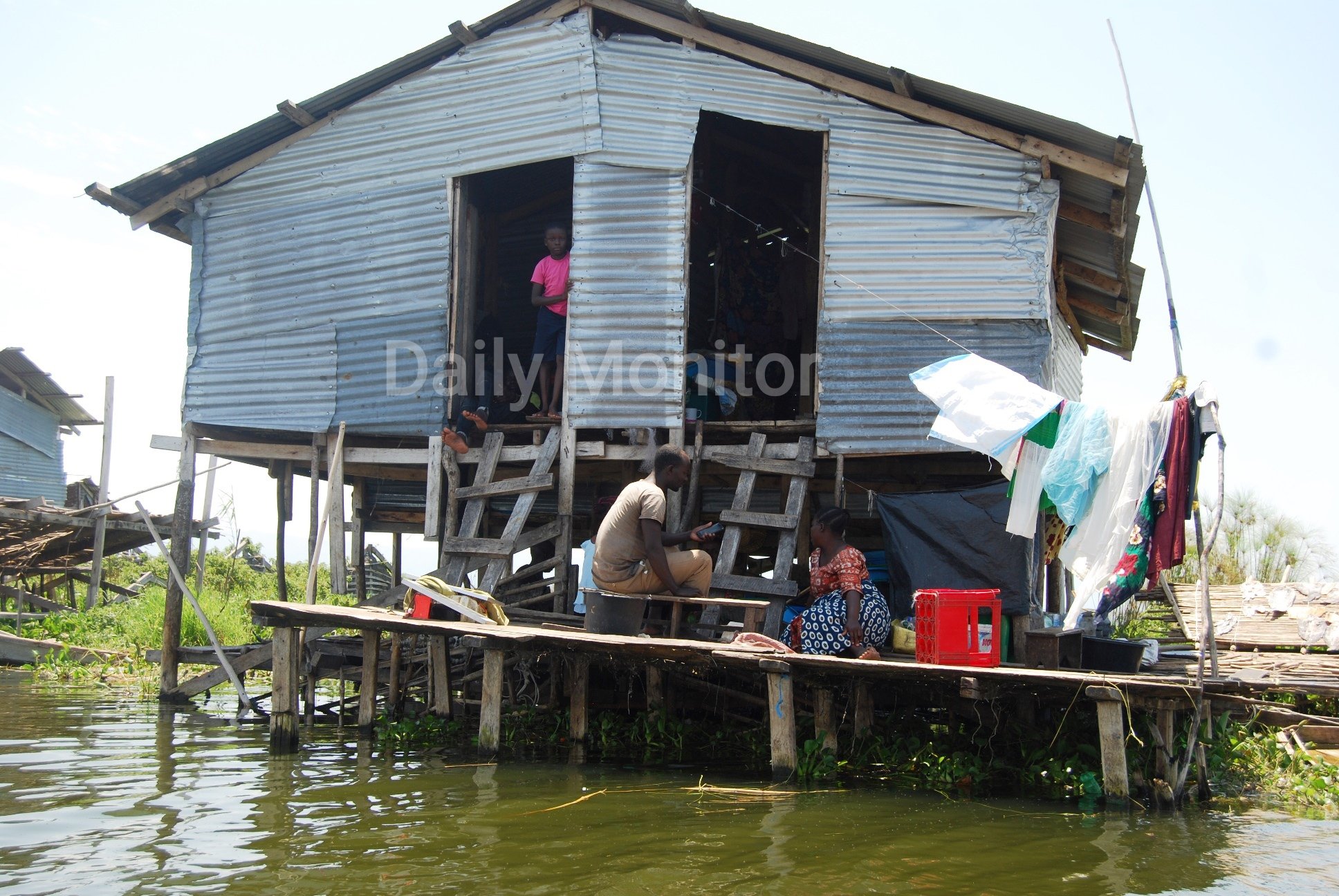
A family of four on their makeshift house in Kanara Sub-county, Ntoroko District. Flood-displaced victims use boats to access their makeshift houses built in the water. About 17 villages in the sub-county have been submerged since 2019. PHOTO / ALEX ASHABA
What you need to know:
- The Lake Albert basin that lies at the parallels of Uganda and the DR Congo, is a jewel in the western rift valley’s crown. But as a result of drastic climate change, the tide on the lake began to rise in October 2019 and resulted into a humanitarian crisis as a deluge submerged several villages in Ntoroko District—displacing thousands of people and destroying property. Thousands of residents are living in pitiable conditions in camps, others were left to fend for themselves, and some are living in appalling conditions in makeshift homes elevated inside the lake, as Frederic Musisi, Alex Ashaba, and William Kintu found out.
Sixty three-year-old Bezwel Ouma has lived through a number of catastrophes in Ntoroko District. However, they pale in comparison to the trail of destruction left by these raging waters.
“There have been rainy seasons like no other and dry spells. In my many years of living here, the lake has never behaved like this and treated us this badly,” a desolate Ouma recounted.
After toiling on the lake as a fisherman, Ouma retired when he clocked 40 years. From savings and borrowing, he put up a commercial structure which also doubled as home, barely a kilometre from the Lake Albert shoreline. He earned about Shs1 million monthly from rent, and life was generally good.
But his business was thrown into a tailspin when the lake’s waters barreled across the landscape and submerged his home.
Five villages were severely affected and eight others submerged partially.
Two years later, Ouma is isolated in an improvised shelter made out of ridges, sisal sacks, and torn tarpaulin, which he built on a piece of land owned by the Anglican church.
“Imagine I am now a squatter on church land, but then where can I go? I am totally hopeless and dependent on what God brings my way,” he narrated. He can barely afford a meal so he eats once a day, like many residents living in a camp established a spitting distance away, often foraging whatever they can find and or relying on the goodwill of non-governmental organisations (NGOs).
Further to the west of the village lies Semliki Wildlife Reserve, which is restricted to human settlement.
Several residents lamented that the wild animals “live better than them” while district officials say a proposal to de-gazette part of the reserve for human settlement was rejected by both the ministries of Local Government, and Tourism, Wildlife and Antiquities.
According to the Ntoroko floods assessment report, the deluge displaced more than 10,000 people in two—Kanara Town Council and Kanara Sub-county, respectively.
The district, according to a recently released National Risk and Vulnerability Atlas, is among the most prone to all natural calamities; floods, earthquakes, landslides, hailstorms, windstorms, drought and lightening.
Submerged
Mr David Kor, the Kanara Town Council mayor, told Daily Monitor that 2,000 people were affected in his area.
“Unlike elsewhere where people usually encroach on wetlands or live on the shores, in our case, we were attacked by the lake,” Mr Kor said.
“Office of Prime Minister (OPM) has been sending some relief—especially food—but it comes after three months or longer or when NGOs and other organisations come to our rescue. These people are on their own; government has really abandoned them.”
He added: “But you here how government is eagerly waiting on and promising hospitality for Afghan refugees, [evacuees] when its own people are living like this! How can Ugandans live like this for two years when refugees elsewhere are living better?”

Then State minister for Disaster Preparedness and Refugees Musa Ecweru (right) tours a flooded area in Rwangaru Sub-county in Ntoroko District last year. PHOTO/FILE
Ntoroko, which lies within the Lake Albert basin, was among the most affected by the rising water levels. At the peak of the water levels across major lake basins in the country early last year, the Ministry of Water and Environment postulated that while Lake Albert was “not expected to reach critical flooding levels” surrounding districts of Hoima, Buliisa and Ntoroko would be affected.
Lake Victoria water levels, which started rising in October 2019, shot to 13 metres as a result of rising temperatures in the Indian Ocean leading to intense and prolonged rainfalls. It had last recorded this rise in 1964.
Similarly, Lake Kyoga exceeded the highest historical water level of 13.2 metres and as such shorelines, swamps and flood plains were submerged.
Lake Albert forms part of the River Nile ecosystem. This stretch known as the Albert/Upper Nile, journeys northwards to the South Sudan border and further through Sudan and Egypt to the Mediterranean Sea. The lake’s main inflow is at the south end through River Semliki which flows from the Mufimbira mountains in DR Congo through Lake Edward, augmented by streams from the Rwenzori ranges.
Ntoroko, which lies in the Rwenzori ranges and comprises of both highlands and a vast expanse of lowlands towards the lake, was severely affected.
The district chairperson, Mr William Kasoro, told this newspaper there is no indication of the water levels receding, resulting into trepidation among residents. Those who have lived long enough at this backwater compare it to the 1960s when rising waters submerged villages and began to recede after a decade.
“The majority have nowhere else to go,” Mr Kasoro said, adding: “The situation is appalling, especially for those communities still living inside the water with no sanitation facilities and basic services. Others who are not in camps are renting small pieces of land at Shs50,000 which is not sustainable because they were not working at all.”
Ironically, Kanara Town Council which is one of the severely affected is categorised as among the only two “least vulnerable” areas by the district disaster profile by the OPM’s Northern Uganda, the National Emergency Coordination and Operations Centre (NECOC).
A forsaken people
The 2016 NECOC’s disaster risk profile detailed Kanara Sub-county to the east of Kanara Town Council among the areas with medium vulnerability. Today, 85 per cent of the sub-county’s expance is submerged.
Some of the most submerged villages include Kamuga, Rwangara, Kanara, Ntoroko west, Kachwakumu, Kataga, katolingo, and Mulaga.
Officials from OPM including ministers toured the area earlier on this year, but preferred to visit only one village on land where a camp for the affected residents was established. Upon learning that they were supposed to ride on rickety boats to reach the shoreline of other affected villages, they abandoned the trip and promised to return after securing a helicopter from the UPDF to fly over the area.
“We are still waiting for them to return to see how the people are living,” said the Kanara sub-county chairperson Friday Mugisa.
“Many residents have nowhere else so they improvised makeshift houses within the flooded part, after all that was their land; there are more than 150 households living in water,” he said.
Kamuga Village, one of the worst affected, is entirely submerged—about three meters or nine feet. Three years ago, one drove to the village; today one has to take a 15-minute ride on a boat across floating water weeds, and other floating debris to get here.
We rode in a boat to Kamuga where we found a community, which was occupying 46 makeshift homes. The village chairperson, Mr Herbert Mwebembezi, said government officials who visited the area promised to “urgently do something, but that is it.”
“For some of us, this was our land. The lake was far away; when it came to us, we didn’t have anywhere to go,” Mr Mwebembezi said, adding: “Other people live inside boats.”
In Kanara Sub-county, Mr Mugisa said the deluge affected 7,000 people, and at least four villages are totally submerged. “I think government abandoned these people,” he said.
Communities living in the submerged villages now live in squalor without basic services such as healthcare. At the beginning of this year, the Kanara Sub-county head offices in Rwangara Village was submerged and Rwangara Health Centre III was closed after it was flooded.
Floods also submerged primary schools such as Rwangara, Umoja, Kachwakumu and other facilities in the area.
To move from one home to another, one has to keep the balance on rickety wooden structures which act as bridges. Residents also keep measuring the water level to avoid any eventualities such as being carried away.
There is also no boundary between the flooded villages and the lake which makes it more dangerous. Safe water has to be boiled or fetched from the land.
To use sanitation facilities such as toilets, one has to route around on a boat to any of the floating islands. Men dive into the lake to take a bathe while women hide behind floating papyrus on the lake to take a bathe.
Mr Kasoro admitted that the living conditions are pitiable.
“I have been in office for about three months. We need to package the solution to this problem well, first by establishing who is vulnerable and who is not; I know some of those people living inside the water are doing so because they derive livelihood from the lake.”
Bleak future
Mr Kasoro said the working plan is to convince the central government on a two-pronged approach; secure land in the nearby least vulnerable districts and relocate those willing, or to de-gazette a small part of the either the Semliki Wildlife Reserve or the adjoining Semuliki National Park, as the new settlement area for the affected communities.
Daily Monitor counted several households with more than 10 family members who dangerously cram in small rickety houses elevated on old timber inside the lake rising at nine feet. Residents revealed that there have been a few accidents, but without viable alternatives—like affording to rent small portions of land—this will remain their home for a foreseeable future.
Residents in the submerged villages also recounted how the UPDF recently rounded up several boats. Uganda and neighbouring DR Congo in March established a cross-border fisheries monitoring team on lakes Albert and George at the border to eliminate illegal, unregulated and unreported fishing.
The two governments indicated that the joint patrols will be conducted on the lake to protect the breeding areas—covering the deep waters from the landing sites. In Uganda, the operations stretch from the Lake Albert island of Mulango in Ntoroko northwards to Kikuube District while on the eastern DR Congo side, they stretch from the disputed Rukwanzi Island.
Mr Yuster Kengonzi, a resident of Kamuga Village, said this has brought more suffering to communities.
“The government has not helped us that is why we are living on the lake. Now the army is taking our boats and yet it’s the means of transport we use,” Ms Kengonzi said.
The State Minister for Relief, Disaster Preparedness and Refugees, Ms Esther Anyakunu, recently visited the affected area and said while government is planning to relocate the affected people from one district to another “these people want to remain in the same district.”
Yet these changes are inevitable and irreversible in a country where human activity including illicit logging and wetland encroachment continues to ravage the fragile eco-system.
Livelihood dilemma
Ntoroko District’s main economic activity is fishing and cattle keeping. The livelihood of locals was greatly hit since the floods affected livestock farming.
Accessing health centres is also a big challenge and they have to hire boats to reach Butungama or Rwebisengo sub-county for medical service. The nearby Rwangara Health Centre III was submerged.
Dr James Kato, the officer-in-charge of Rwebisengo Health Centre III, in April said they have to travel long distances to pick drugs.
Mr Byaruhanga said since 2019, they have been requesting the government to relocate them to Toro Semliki Wildlife Reserve.
The chairperson of Kachwakumu Village, Mr Rwaheru Byaruhanga, said while some people sought refuge with friends and family, others have nowhere to go. He said more than 200,000 houses were still submerged and only rooftops could be seen floating on top of water.
“Our people have risked their lives because any time, these makeshift houses may collapse. They will also contract disease because they use contaminated water,” Mr Byaruhanga said.