A desperate struggle to manage floods
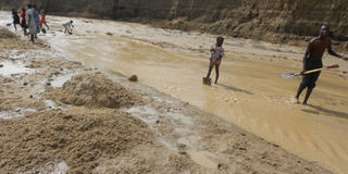
Sand mining in the L. Albert catchment. Photo by William Balikuddembe Odinga
What you need to know:
In May last year, floods displaced and killed several people in Bundibugyo, Kasese and Ntoroko districts. But there is a bigger story unfolding before our eyes.
It is 6am. The calendar on the wall reads September 24, 2014. Water quality specialist Jackson Kitamirike awakes in his hotel room on the second floor and takes a stride to the window. He looks down. The ground is wet, typical of this western Uganda town of Fort Portal.
Kitamirike has today got to collect water samples from several rivers and streams for routine tests. Besides, just next door, there is a journalist he has to lead into a story – a story of a nation’s struggle to manage water. That story is here in the northern part of the Albertine Rift valley where the Rwenzori Mountains, also known as Mountains of the Moon, stretch their arms.
In May last year, floods killed and displaced several people in Bundibugyo, Kasese and Ntoroko districts, just as had happened the previous year and the year before that. Roads, bridges, buildings and farms were destroyed. Those incidents made news. But there is a bigger story unfolding before our eyes.

A neat tarmac road meanders into and through slightly misty hills to the west of Fort Portal. It curves in some parts to expose deep gullies and green vegetation below it. Here and there, men emerge from uphill with sacks of charcoal hanging by straps from head to back. They walk sideways, one step up and two steps down, to negotiate the steep slopes. This road is their market place where they sell to travellers.
A turn to the right, in less an hour’s drive, takes Kitamirike straight into Kiringa wetland, in Ntoroko District. Here, by the River Semliki, he stands still for a few minutes observing the water flow and things around him – the grass, the cows, the people, and an army of red ants marching near his left foot.
“Across the river is the Democratic Republic of Congo (DRC). The vegetation there is intact,” says Kitamirike, gesturing with his right hand. “Now look where I am standing. This is Uganda, highly degraded. Overstocking has contributed to what we are seeing here.”
A small tribe, the Batuku, inhabits this area. In this swamp they graze their cattle and from the Semliki their animals have drunk water for generations. The Batuku and their animals have been increasing in number but their territory has not expanded. This partially explains the massive pressure on the river bank.
The Semliki looks calm at the moment but it is sly. Beneath its surface are soil particles and other sediments it has carried from as far as Lake Edward on its 140km journey to Lake Albert.
Some are from the Rwenzori Mountains, carried down by the rivers Mubuku and Nyamwamba, through Lake George, the Kazinga Channel, Lake Edward and eventually into the Semliki. It deposits them in Lake Albert where they are contributing to the siltation of its southern part.
“There is evidence from the 1960 topographic maps, spot image of 1980 and Landsat TM image of 2000 that the delta on the southern shoreline of Lake Albert is expanding into the lake due to siltation from River Semliki. From 1960 to 1980 it expanded 3.5km and from 1980 to 2000 it expanded 2km,” states the Uganda Atlas of Our Changing Environment published by the National Environment Management Authority (NEMA) in 2009.
The Mubuku and Nyamwamba have previously been bursting their banks and flooding parts of the Albert catchment. But with extensive and continuous environmental degradation of mountain slopes and in the valleys, driven by the felling of trees for timber and charcoal, clearing of land for cultivation, mining of sand for construction, and encroachment on river banks for crop and animal production, the speed at which these rivers are sweeping things away, both living and nonliving, and becoming polluted with dangerous metals and chemicals, is increasing.
At Kilembe mines in Kasese district for example, the Nyamwamba is washing stockpiles of copper into the Mubuku valley and Lake George, releasing the metal into the food chain.
In humans excessive exposure to copper is linked with liver damage and kidney disease, among other effects. A concrete mark at the riverside indicates that when the copper waste was dumped there over three decades ago, it was not anticipated that Nyamwamba would ever rise to the level of the stockpiles.
Gradually, as the Semliki finds an easy path through Uganda’s degraded soil, it is slicing off parts of Uganda and adding territory to the DRC with the potential to cause future territorial conflicts between the two countries. Over 10 metres wide of the river bank on Uganda’s territory is eroded annually at various points of the Semliki, according to the Uganda Atlas of Our Changing Environment.
Moving to correct the wrongs
In 1992, after the Rio Earth Summit and reflecting the new emphasis of Agenda 21, Uganda started to implement a concept called Integrated Water Resources Management (IWRM).
This is described by the Global Water Partnership (GWP) as a process which promotes the coordinated development and management of water, land and related resources in order to maximise the resultant economic and social welfare in an equitable manner without compromising the sustainability of vital ecosystems.
The idea in IWRM is to bring together different water users, from the common person to the industrialist, including you and me, acknowledging that water is a common good, that is finite, and in the use of which we humans must not deprive each other or the ecosystems of quality and quantity.
It is in this spirit, where every water user has a say and responsibility, that in 2012, here in Kiringa wetland, the World Wide Fund for Nature (WWF-Uganda), through the Semliki River Catchment and Water Resources Management Project, mobilised different groups of people to restore the river bank vegetation as part of IWRM.
Cattle keepers, crop farmers, local government workers, bricklayers, industrialists and several others, classified as water users, planners and policy makers, were called into action. Uganda’s environmental law grants a buffer of 100m from major rivers for environmental protection and this is where WWF and the groups planted trees. One hundred metres wide they spread, two kilometres long they stretched, with different tree species.
The Semliki, augmented by the force of water flowing from the Rwenzoris, swelled soon after, bust its banks, and swept through, ripping up every sapling. To those who had participated in the tree planting, it was a rude reminder that the water management task ahead of them was huge.
The IWRM concept is largely understood to have emanated from the International Conference on Water and the Environment (Dublin 1992) and the Earth Summit (Rio 1992). In reality however, it was baked a bit earlier in Copenhagen, Denmark, in what were known as the Nordic Freshwater Initiatives.
“The Copenhagen Conference and Statement in late 1991 strongly influenced the Dublin principles and Agenda 21,” says Dr. Torkil Jonch-Clausen, Chief Policy Adviser DHI Group and Senior Adviser GWP.
“Led by Mr. Kabanda [then PS Ministry of Water and Environment] and technically and financially supported by Danida, Uganda embarked upon the world’s first Water Action Plan (WAP) in 1993-1994, before IWRM was really defined as such, but building the foundation for it by adhering to the Dublin-Rio principles,” adds Clausen who helped Uganda in developing that action plan.
A range of laws and policies on water and natural resources followed the WAP. These included the Water Statute (1995), the Water Policy (1999) and the National Environment Act (1995) as well as regulations including the Water Resources Regulations, Water Supply Regulation and the Environmental Impact Assessment Regulations.
“Previously water resources were in the Land Act and this was not clear. In 1994 and 1995 we had the environmental policy and law. We had sufficient ground to promote water resources management,” says Eng. Patrick Kahangire, the head of the Directorate of Water Development (DWD) at the time of IWRM introduction.
But 12 years after the introduction of IWRM, a review of water management resulted in major adjustments. Based on the 2005 Water Sector Reform Study, Uganda was divided into four zones, called Water Management Zones (WMZ) in pursuit of effective IWRM. The zones include Victoria, Kyoga, Upper Nile and Albert, based on hydrological catchments or basins. It was a swift shift from centralised water management to management of water at catchment level.
“When we did the study there were recommendations that maybe we start small. But we said we are starting the future. So we decided to start in all the four zones. We called it the ‘big bang’,” says Eng. Kahangire.
Exciting as the bang may have come, Uganda’s WMZs are straggling to walk ahead nearly 10 years later, and IWRM remains at low momentum over 20 years after it was introduced.
IWRM in practice
In July 2011, a team of six including Kitamirike, led by Principal Water Officer Albert Orijabo, arrived in Fort Portal from the Directorate of Water Resources Management (DWRM) in Entebbe.
They were tasked to set up the Albert Water Management Zone (AWMZ) technical office and were given a small room at the Ministry of Water and Environment (MoWE) Technical Support Unit (TSU) 6.
In the IWRM structure Kitamirike and colleagues are the technical people in the WMZ, representing the MoWE. Below them are river Catchment Management Organisations (CMO) with Catchment Management Committees (CMC) comprising people of different interests.
Next are Water User Associations, comprising Water User Groups which are at the bottom of the pyramid. This structure makes water management more of everyone’s business as it emphasises participation of water users, planners and policy makers at all levels in the development and management of water. With competing interests for water and limited understanding of the IWRM principles, however, implementation of IWRM in Uganda is no easy task.
Most Ugandans live hand-to-mouth and directly off natural resources – tilling the land to produce food, cutting trees to produce energy or mining the earth to feed the construction industry. The options for survival, especially in rural areas, are very limited.
“IWRM principles are looking at conservation but there is the issue of poverty and livelihood. You are telling people ‘don’t make bricks here’ or ‘don’t cut trees’ but they have to pay for their children school fees,” says Orijabo, the Team Leader, AWMZ.
Besides common people’s poverty, institutional weaknesses — structural, financial and technical — have meant slow understanding and acceptance of IWRM in Uganda.
“With decentralisation, now we have districts with no resources. You may also find 39 districts in a water management zone. It is a nightmare coordinating them,” says Kahangire.
At the lower levels of the local government, structures that should spread the understanding of IWRM are weak.
“At village level the only person working is the LC 1 Chairman. You can’t even know that there is an executive committee,” says Clovis Kalengutsa, Chairman, Mubuku-Nyamwamba Water User Association. “The local government has civil servants including Community Development Officers (CDOs) but many of them did not even know that water user groups existed in their areas.”
With the current level of funding – which Kahangire says the central government must address if IWRM is to work – local governments cannot afford to finance natural resources management activities.
“Local government gives me a budget of Shs100,000 (about $37) a year and at times they tell me they have not realised the budget estimate in my sub county so I don’t get anything,” says Hamda-Saadi Kibuuka, CDO, Karusandara Sub county, Kasese District.
At the upper end of government, coordination of relevant ministries and agencies in IWRM is found wanting.
“There is a silo structure at the top,” says Dr Tom Okurut, Executive Director, Nema. “After the big push of [Lake Victoria Environmental Management Project] LVEMP1, MoWE remained the key champion of IWRM and that is where problems came in. Right now water management zones are bringing other professionals on board but elsewhere people are looking at IWRM as a water affair.”
Orijabo describes the IWRM process as “long and tedious.” “If for example you want to install a borehole you can directly do that and the water will flow. Under IWRM you have to talk to communities, go into studies, establish the water balance, go into institutional development etc. Establishing IWRM in the Semliki catchment took four years with massive funding,” he says.
Dr Alan Nicol, a researcher, and Programme Director, Global Water Initiative East Africa (GWI EA), says IWRM is important but it is early days to be working effectively in Uganda. It will take time, he says.
“The potential for natural hazards to increase in Uganda is quite high. There has been so much change in the last two decades with population growing by a million people per year since 2000 and people moving to marginal lands,” says Nicol. “IWRM can work through understanding of the underlying political economy to enable good decision making on water. But is there sufficient knowledge at the local level?”
According to Nicol, Climate Change presents a new opportunity and necessity for IWRM implementation in countries such as Uganda.
“It looks like targets on global emissions reduction are going to be missed. Climate Change will be the new driver of IWRM turning the concept into a necessary approach – but only if it takes on board critical development challenges and needs at a local level – most notably sustainable poverty reduction,” says Nicol.
As Kitamirike promotes IWRM, he should find encouragement in his former boss Kahangire’s words: “We know that this [IWRM] is going to take time. These are young arrangements.” But is time on Uganda’s side?
Quick notes
1. Rio Earth Summit: United Nations Conference on Environment and Development (UNCED), Rio de Janeiro, 3-14 June 1992.
2. Agenda 21 is non-binding, voluntarily implemented action plan of the United Nations with regard to sustainable development. It is a product of the Rio Earth Summit.
3. Dublin principles: 1) Fresh water is a finite and vulnerable resource, essential to sustain life, development and the environment; 2) Water development and management should be based on a participatory approach, involving users, planners and policy-makers at all levels; 3) Women play a central part in the provision, management and safeguarding of water; 4) Water has an economic value in all its competing uses and should be recognized as an economic good.