Brace for more floods in Katonga, Lwera catchment areas – NEMA
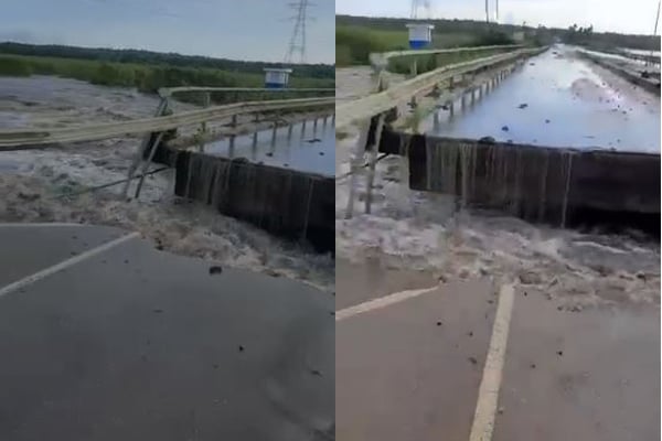
A video grab showing the broken Katonga river bridge after flash floods cut off Kampala-Masaka road on May 11, 2023
What you need to know:
- Katonga Bridge, which is a major gateway to key regional borders like Tanzania, DR Congo, Rwanda and Burundi, caved in last Thursday following devastating flash floods that swept through the area.
Dr Yahaya Barirega Akankwasah, the Executive Director of the National Environment Management Authority (NEMA), has warned residents around the Katonga catchment area to expect more floods even after the current rains have subsided.
Katonga Bridge, which is a major gateway to key regional borders like Tanzania, DR Congo, Rwanda and Burundi, caved in last Thursday following devastating flash floods that swept through the area.
“Preliminary inspections show an anticipated increase in the volume of water in River Katonga in the near future. This phenomenon can be attributed to the rising water levels observed in other tributaries of Katonga, as well as Lake Wamala, which contributes its waters to the Katonga system,” he said.

The Katonga catchment system, which includes; River Katonga, extends an estimated area of 13,837 square kilometres and is characterized by numerous tributaries and distributaries. It encompasses several districts, namely; Mubende, Mityana, Kalungu, Gomba, Sembabule, Kyegegwa, Kamwenge, Kyenjojo, Kiruhura, Lyantonde, Lwengo, Mpigi, Masaka, Kyotera, Bukomansimbi, and Butambala. The river's waters flow into Lake George and Lake Victoria.
Dr Barirega while elaborating on the probable causes of the flooding and subsequent destruction of the bridge (Katonga) connecting the southwestern region of the country, said NEMA is currently engaged in evaluating the entire Katonga catchment area to analyze the landscape and identify potential impacts and explore potential long-term solutions.
“As the water inflow into Katonga increases, the amount of water pouring into the Lwera catchment area will also significantly rise. If appropriate measures are not taken, there is a risk of the flooded area eventually connecting to Lake Victoria,” he said.
He, however, explained that the ongoing flooding cannot be directly attributed to sand mining activities in the Lwera areas.
“Sand mining activities alone could not have caused this kind of flooding, but taking into account the lessons learned from previous errors, the government has made the decision not to extend any permits for sand mining and rice farming in the Lwera region. There are currently only two companies with active permits, but once their permits expire, they will not be renewed,” Dr Barirega said.
According to Dr Bob Ogwang Alex, the Acting Executive Director of Uganda National Meteorological Authority (UNMA), the recent floods can partly be attributed to the abnormal rainfall patterns experienced in the area over the past three months thus increasing the water volumes flowing into the River Katonga.