Prime
13,000 displaced as floods hit country
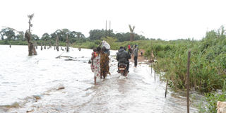
A section of Kazzi Malanga Road in Kalangala District, which has been reclaimed by Lake Victoria. PHOTO | DAVID SSEKAYINGA
What you need to know:
- The Uganda National Meteorological Authority projected that certain parts of Uganda would receive torrential rains, and urged leaders and locals to prepare for disasters.
Torrential rains have triggered fresh floods in different parts of the country, destroying houses and cutting off roads.
According to the preliminary assessment by the Uganda Red Cross Society, 18 deaths had so far been recorded and more than 13,000 people were displaced in different districts across the country by last weekend.
The most affected districts include Katakwi where 3,232 were displaced followed by Kanungu with 3,090 and Bulambuli with 3,073 people. Others are Ntoroko (1,500), Kisoro (1,200), Kasese (1,132) and 668 people in Kayuga.

The communication officer of Uganda Red Cross Society (URCS), Ms Irene Nakasiita, told Daily Monitor that the organisation is still conducting the assessment of the damage caused by floods and mudslides.
By Thursday afternoon, officials of Uganda National Roads Authority (Unra) Kabale station had ordered closure of the flood-damaged Kabale-Rubanda-Kisoro Road after a section curved in at Hamurwa Village in Rubanda District.
The road connects to Rwanda through Chanika and the Democratic Republic of Congo via Bunagana.
The Unra station manager for Kabale are, Mr Alison Abenabo, on Thursday said they had diverted traffic to Kabale-Katuna-Rubaya-Muko-Kisoro Road following the impact of the torrential rains last week.
“The traffic flow has been diverted so that we can work on the damaged road section. Many road sections in our region have been cut off because of the recent heavy rains and most of the sections have been fixed,” Eng Alison Abenabo said.
A truck driver, who uses the Kabale-Rubanda-Kisoro Road twice a week to transport fresh foods, Mr Mugisha Byaruhanga, said the alternative route is far and expensive.
“Kabale-Rubanda-Kisoro is only 75Km while Kabale-Katuna-Muko-Kisoro is about 130Km. This means that fuel consumption shall be doubled when I use the alternative route. We pray that the damaged road section is fixed as soon as possible,” Mr Byaruhanga said.
The Kisoro resident district commissioner (RDC), Hajj Shafiq Ssekandi, said they have asked the people living in the valleys and lowlands adjacent to steep slopes to vacate and get temporary accommodation at churches and some government institutions.
Deaths
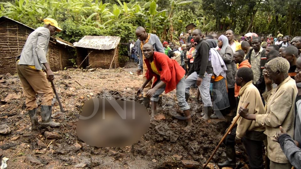
On Tuesday, mudslides killed eight people from Murora Sub-county in Kisoro.
“We have advised people living in valleys and on the lowlands to vacate as we wait for the food and non-food relief items from the Office of the Prime Minister as already promised,” he said.
He, however, said:“We are continuing to persuade them (some people who have refused to vacate) to avoid any further loss of lives.”
In Rukungiri, at least three people have died and in Mbarara City, several bridges have been washed away by floods triggered by torrential rains.
The Kagorogoro Village chairperson in Rukungiri, Mr Alex Mugisha, said the deceased were distilling local brew (waragi) when River Rushaya burst its banks.
The deceased were identified as Edson Ngabirano 30, Bonny Kyabaasi 64, and Francis Kabale 90. They were all residents of Bwambara Sub-county.
Mr Mathias Tugume 33, an elder brother to the late Ngabirano, said he was shocked by the floods.
“I think it rained somewhere in Mitooma District where this river originates because here in Bwambara it never rained at all,” he said.
In Mbarara City, the bridges that have been washed away include Kanyeyite, Kitobero, and Katete. As a result, locals are stranded.
“We request the city council to help us work on this bridge because it is being used by many people,” Mr Felix Basasibwakyi, a boda boda rider said.
Mr Everist Muhumuza, a resident of Katete, said the water levels are high, adding that they fear they might wash away houses.
“River Rwizi’s water levels have gone high as you can witness. So far the small bridge has been covered by water, now the main bridge is almost getting covered with running water,” he said.
The Mbarara City environmental officer, Mr Joseph Mwesigye, said the area was hit by abnormal rains that have increased the water level of River Rwizi leading to an overflow.
“These abnormal rains that we received have been caused by global warming because our people have encroached on the wetlands and this will continue to happen if we do not enforce laws to protect the wetlands,” Mr Mwesigye said.
Affected rivers
In Kasese District, five people have so far died in one week, with Karusandara, Bulembia Division, and Buhuhira as the worst-hit areas.
The flooded rivers include Muhokya, Mubuku, Sebwe and Nyamwamba.

The deceased include a four-year-old girl Benon Kisembo 20; Alfred Mbonimb, 41, who are all residents of Karusandara Sub-county.
Meanwhile, Robert Masereka’s body was also retrieved from River Muhokya. He was a resident of Kyamiza Village in Muhokya Sub-county.
Also the body of 11-year-old Anthony Bwambale was retrieved from a valley on April 30 in Katerera Village, Kitabbu Sub-county, where he had gone to collect firewood.
Last Tuesday and Wednesday, River Mubuku burst its banks and cut off Karusandara Health Centre III in Karusandara Sub-county.
Ms Moreen Mbambu, a midwife at the facility, said by Wednesday afternoon activities at the facility were paralysed because of floods.
“Patients who were supposed to visit the facility on Wednesday did not turn up because all the major access roads leading to our facility were cut off by floods,” she said.
In Ntoroko, more than 600 people from at least 10 villages were rendered homeless after River Semliki burst its banks on April 30.
The most affected villages are in Rwebisengo and Bweramule sub-counties,which are in the cattle corridor.
The internally displaced people since Sunday have been sleeping under trees, and in the middle of the road together with their properties because they have nowhere to go.
The most flooded villages include Kayanja 2 &3, Kyobe, Masaka, Karugaju, Budiba, Masojo, Rukora, Kiraga, and parts of Butungama and Rwebisengo sub-counties. The flooded villages neighbour River Semliki, which is about 5Kms away.
The Ntoroko District chairman, Mr William Kasoro, said the number of people who are displaced may reach 1,000.
“As a district, we don’t have any help to give to the displaced people. They have been sleeping under the tree shades while others are in the middle of the road, which is risky,” he said.
In Bundibugyo, 30 villages in Kirumya sub-county have been experiencing landslides since last year.
Looming disasters
The Kirumya sub-county chairman, Mr Abraham Bamwiterebye, said apart from the sinking of the land, people’s houses have also started developing cracks.
In Kalungu District, houses and shops have been submerged by floods.
In Lukaya Town Council, a major business hub in the district, traders have since Tuesday been draining water out of their flooded shops and cleaning their merchandise in the aftermath of the downpour.
According to Mr Fazil Jjingo, a businessman, the heavy rains which have pondered the area for three consecutive days resulted in Katabazungu stream submerging houses on May 1.
“Merchandise in different shops has been destroyed and many businesses are almost at a standstill,’’ he said.
Different residents attribute the flooding to corruption which led to the illegal construction of structures that interfere with the normal flow of the stream.
“Lukaya is steadily developing and those constructing houses chose to encroach on the banks of the stream and this is why we are suffering now,” Mr Sam Ssekito, a trader said.
At Kamuwunga Village, located within Lwera Swamp on the Kampala –Masaka Highway, many homes and household items have been destroyed
According to Mr Ronald Ssemanda, the chairperson of Kamuwunga landing site, when it started raining on April 29, which was a Saturday, they thought it was the usual rain, but it continued on both Sunday and Monday.
Both farmers and sand miners in Lwera dug trenches into the swamp which pour its waters into Lake Victoria.
“We are lucky that no death has been recorded, but the situation is likely to worsen if it continues raining in the coming days,” Mr Ssemanda said.
In Wakiso, floods have cut off a four-kilometre road that links Buloba to Nsangi Town Council on the Kampala-Masaka Highway.
The road was cut off after torrential rains caused the banks of River Mayanja on Lake Victoria to burst its banks.
The district works department had two years ago spent close to Shs2b to erect permanent box culverts at River Mayanja. This road connects the Kampala-Masaka Highway to the Kampala-Mityana Highway.
According to Mr Sam Mwesigwa, the Wakiso District engineer,they now need to raise the ground and ensure that water at River Mayanja flows freely.
He said other swamps which have flooded include Nakiduduma on Buloba –Kakiri Road and Nakabugo on Wakiso -Ssentema Road.
In Mpigi and Butambala , River Muyanga, which connects both districts, burst its banks affecting the transportation of agricultural goods to different markets in Kampala.
The floods have also displaced locals after 12 houses collapsed in Kikandwa Village in Ngando Sub-county in Butambala District.
Ms Rashidah Namboowa, the chairperson of Butambala District, said they cannot handle this magnitude of the disaster and have since petitioned the Office of Prime Minister (OPM) to intervene.
“Some of the families are being housed by neighbours and on top of that, they also lack food since the floods submerged their gardens,” she said.
In Gomba, River Sembula also burst its banks making many feeder roads in the district impassable.
In Kalangala District, 500 metres of Kaazi-Malanga Road on Buggala Island have been reclaimed by the lake affecting transport from Kalangala Town to various landing sites.
In Kyotera, the persistent heavy rains have so far washed away three bridges at Kisuula and Kijonjo swamp on Kasasa -Kabira Road.
Ms Agnes Namayega, a councillor representing Kasasa Sub-county at Kyotera District council, said: “Our farm outputs cannot get to markets now. We are calling for urgent intervention.”
In Adjumani District, the implementing partners have embarked on training farmers on early warning signs to mitigate the floods in their farmlands.
The district environment officer of Obongi, Mr Henry Unzima, said they warned people not to settle in the flood-prone areas.
The district in 2019-2021, experienced the worst flood in history where several homes were swept away when River Nile burst its banks.
In Yumbe District, Mr Rasul Drajiga, the disaster committee chairperson, said at the moment, no cases of floods have been registered in the district.
“We have sent out leaders to sensitise the communities to refrain from digging close to the river banks because such activities lead to the bursting of the rivers banks,” he said.
The chairperson of Bududa District, Mr Milton Kamoti, said the district is currently experiencing high rainfall of more than 1,500mm.
“There is high precipitation and surface runoff, which leads to landslides and flush floods given the topography and hilly terrain,” he said.
Currently in Bubiita Sub-county, there is about a three-kilometre crack running through several villages to River Tsume, a signal that a disaster could happen in the near future.
Roads cut off
In Jinja, at least two roads have been affected by floods in Butagaya Sub-county.
The Butagaya sub-county chairman, Mr Abdallah Suta, said the road leading to Busowoko tourism site has been cut off after heavy rains destroyed the culverts.
The acting Executive Director of Uganda National Meteorological Authority (UNMA), Mr David Elweru, in his March to May 2023 seasonal rainfall outlook warned about flash floods, waterlogging, landslides, lightning strikes, and strong winds in southwestern Uganda.
“The predicted rains require action in sufficient time and in an appropriate manner so as to take advantage of the information. This forecast should be used for planning in all rain-fed economic activities so as to improve economic welfare and livelihoods for our communities in their localities,” the rainfall outlook signed by Mr Elweru, read in part.
The communication officer of UNMA, Ms Lillian Nkwenge, when contacted reiterated that areas of the southwest were particularly warned.
The outlook shows that the rainfall to be received will be between normal to below normal and that this is likely to affect economic activities especially agricultural production and food security.
The authority advises people to avoid crossing flooded road sections, to desilt drainage channels, and asked district officials to update their contingency plan, among others.
The most flood-affected districts are Kabale, Kisoro, Rukungiri, Mbarara City, Kasese district, Ntoroko, Bundibugyo, Kalungu, Wakiso, Mpigi, Butambala, Gomba and Kyotera
Compiled by Fred Wambede, Robert Muhereza, Emmanuel Arineitwe, Julius Hafasha, Alex Ashaba, Moureen Felix Ainebyoona, Ronald Kabanza & Coslin Nakayiira Biira, Marko Taibot and Robert Elema, Al-Mahdi Ssenkabirwa, Noeline Nabukenya, David Ssekayinga & Richard Kyanjo.


